Approximate Location Map
Large Map »
Latitude: 51.8882 / 51°53'17"N
Longitude: 0.8992 / 0°53'57"E
OS Eastings: 599607
OS Northings: 225047
OS Grid: TL996250
Mapcode National: GBR SN5.D5G
Mapcode Global: VHKFZ.JSQV
Plus Code: 9F32VVQX+7M
Entry Name: Numbers 11, 12 and 13 Trinity Street
Listing Date: 24 February 1950
Last Amended: 19 February 1959
Grade: II
Source: Historic England
Source ID: 1337772
English Heritage Legacy ID: 117209
ID on this website: 101337772
Location: Colchester, Essex, CO1
County: Essex
District: Colchester
Electoral Ward/Division: Castle
Parish: Non Civil Parish
Built-Up Area: Colchester
Traditional County: Essex
Lieutenancy Area (Ceremonial County): Essex
Church of England Parish: Colchester St Peter
Church of England Diocese: Chelmsford
Tagged with: Building
1.
995
TL 9925 SE
5/249
24.2.50 and 19.2.59
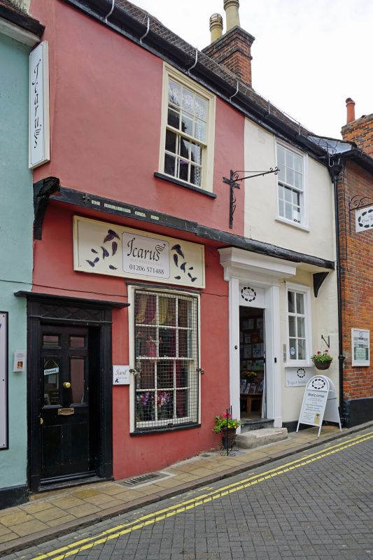
TRINITY STREET
(West Side)
No 11
Nos 12 & 13
II
GV
2.
C16 origin but considerably altered. Inscribed on the front of No 13, 'the
Fleur de Lys circa 1500'. 2 storeys, timber-framed and plastered, tiled roofs.
The upper storey projects on the front of Nos 12 and 13, double hung sash
windows with glazing bars, 1 ground floor flat bow window. No 11 has a modern
brick front.
Nos 2 to 14 (consec) form a group
Listing NGR: TL9960725047
External links are from the relevant listing authority and, where applicable, Wikidata. Wikidata IDs may be related buildings as well as this specific building. If you want to add or update a link, you will need to do so by editing the Wikidata entry.


Other nearby listed buildings
