Approximate Location Map
Large Map »
Latitude: 51.096 / 51°5'45"N
Longitude: 0.5378 / 0°32'16"E
OS Eastings: 577800
OS Northings: 136034
OS Grid: TQ778360
Mapcode National: GBR PTC.BS7
Mapcode Global: FRA D607.3CY
Plus Code: 9F323GWQ+C4
Entry Name: 7, Waterloo Road
Listing Date: 19 May 1986
Grade: II
Source: Historic England
Source ID: 1338665
English Heritage Legacy ID: 169158
ID on this website: 101338665
Location: Cranbrook, Tunbridge Wells, Kent, TN17
County: Kent
District: Tunbridge Wells
Civil Parish: Cranbrook & Sissinghurst
Built-Up Area: Cranbrook
Traditional County: Kent
Lieutenancy Area (Ceremonial County): Kent
Tagged with: Building
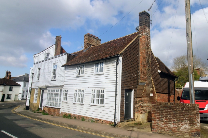
CRANBROOK WATERLOO ROAD
TQ 7736 SE
(north west side)
10/307
- No 7
GV II
Cottage. Early C18. Timber-framed and weatherboarded on brick plinth.
Plain tiled roof with end stacks that to right projecting with set-offs.
2 storeys. Irregular 2 window first floor, C20 casements. Entrance at right
hand end. Included for group value.
Listing NGR: TQ7779736035
External links are from the relevant listing authority and, where applicable, Wikidata. Wikidata IDs may be related buildings as well as this specific building. If you want to add or update a link, you will need to do so by editing the Wikidata entry.


Other nearby listed buildings
