Approximate Location Map
Large Map »
Latitude: 51.8366 / 51°50'11"N
Longitude: -1.8039 / 1°48'14"W
OS Eastings: 413605
OS Northings: 215349
OS Grid: SP136153
Mapcode National: GBR 4QY.SW9
Mapcode Global: VHB27.P36D
Plus Code: 9C3WR5PW+JC
Entry Name: Dovecote C40M North of Stables, Farmington Lodge
Listing Date: 23 January 1952
Grade: II
Source: Historic England
Source ID: 1340767
English Heritage Legacy ID: 130489
ID on this website: 101340767
Location: Farmington, Cotswold, Gloucestershire, GL54
County: Gloucestershire
District: Cotswold
Civil Parish: Farmington
Traditional County: Gloucestershire
Lieutenancy Area (Ceremonial County): Gloucestershire
Church of England Parish: Farmington St Peter
Church of England Diocese: Gloucester
Tagged with: Dovecote
FARMINGTON FARMINGTON VILLAGE
SP 11 NW
1/51
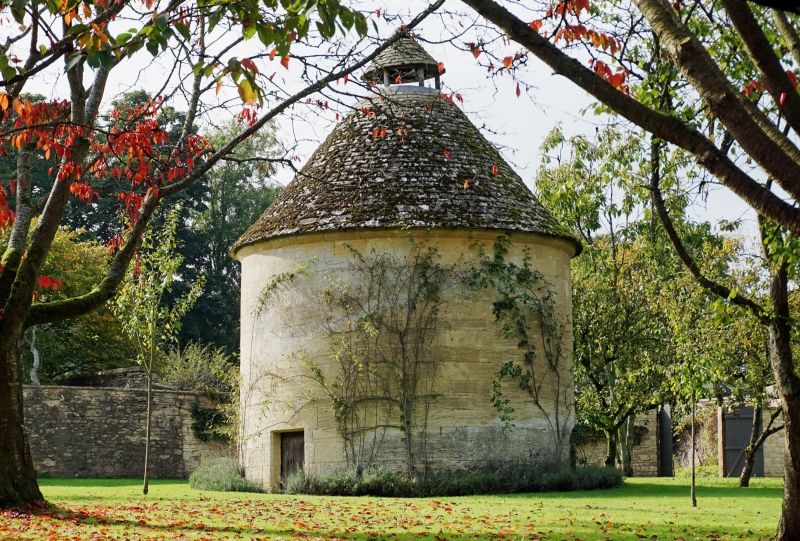
Dovecote c40m north of stables,
Farmington Lodge
23.1.52
GV
II
Dovecote. C18 or earlier. Ashlar, stone slate roof. Circular
plan. Early plank door set back within low rectangular flat-
chamfered surround. Flat-chamfered eaves cornice. Conical roof
with circular lantern also with conical roof at apex. Interior
with pigeon holes and single band forming landing platform.
Listing NGR: SP1360415349
External links are from the relevant listing authority and, where applicable, Wikidata. Wikidata IDs may be related buildings as well as this specific building. If you want to add or update a link, you will need to do so by editing the Wikidata entry.


Other nearby listed buildings
