Approximate Location Map
Large Map »
Latitude: 51.7146 / 51°42'52"N
Longitude: -1.9054 / 1°54'19"W
OS Eastings: 406633
OS Northings: 201772
OS Grid: SP066017
Mapcode National: GBR 3R0.K2K
Mapcode Global: VHB2R.X5KD
Plus Code: 9C3WP37V+VR
Entry Name: Road Bridge over Ampney Brook
Listing Date: 17 June 1986
Grade: II
Source: Historic England
Source ID: 1340997
English Heritage Legacy ID: 129634
ID on this website: 101340997
Location: Ampney Crucis, Cotswold, Gloucestershire, GL7
County: Gloucestershire
District: Cotswold
Civil Parish: Ampney Crucis
Traditional County: Gloucestershire
Lieutenancy Area (Ceremonial County): Gloucestershire
Church of England Parish: Ampney Crucis The Holy Rood
Church of England Diocese: Gloucester
Tagged with: Road bridge
SP OO SE AMPNEY CRUCIS AMPNEY CRUCIS VILLAGE
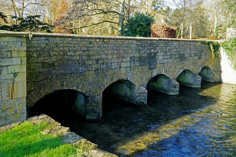
5/12 Road bridge over Ampney Brook
II
Bridge carrying main village street over Ampney Brook. Probably
late C18/early C19. Coursed and dressed stone with angled coping
supported on 4 pointed breakwaters, with 5 small round arches.
Parapet wall about lm high with ends curved back towards Brook at
each corner to square piers. Width approximately 4.5m, length 12-
13m. Site of bridge from medieval period, and intact as built.
Listing NGR: SP0663301772
External links are from the relevant listing authority and, where applicable, Wikidata. Wikidata IDs may be related buildings as well as this specific building. If you want to add or update a link, you will need to do so by editing the Wikidata entry.


Other nearby listed buildings
