Latitude: 51.709 / 51°42'32"N
Longitude: -1.7818 / 1°46'54"W
OS Eastings: 415172
OS Northings: 201164
OS Grid: SP151011
Mapcode National: GBR 4SJ.SF2
Mapcode Global: VHB2V.29DQ
Plus Code: 9C3WP659+J7
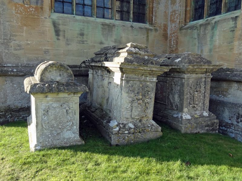
Entry Name: 3 Morean (Possibly Morgan) Monuments Immediately Adjoining South East Corner of Church in Churchyard of Church of St Mary
Listing Date: 17 June 1986
Grade: II*
Source: Historic England
Source ID: 1341028
English Heritage Legacy ID: 129714
ID on this website: 101341028
Location: St Mary's Church, Fairford, Cotswold, Gloucestershire, GL7
County: Gloucestershire
District: Cotswold
Civil Parish: Fairford
Built-Up Area: Fairford
Traditional County: Gloucestershire
Lieutenancy Area (Ceremonial County): Gloucestershire
Church of England Parish: South Cotswold Team Ministry
Church of England Diocese: Gloucester
Tagged with: Monument
SP 1401-1501 FAIRFORD HIGH STREET (west side)
13/158 3 Morean (possibly Morgan) monuments immediately adjoining south east corner of church in churchyard of Church of St. Mary
GV II*
One bale tomb and 2 chest tombs, all to Morean, possibly Morgan or Morear family: Bale, Robert 1728; chests: centre, Edmund, probably mid C18, and north, unidentified of similar style and date. Robert - spiral bale top in 2 sections with panelled central band, shell ends wth eroded carvings in each. Gadrooned capping, moulded plinth. West end has plain shield with initials and date, east end has high relief cartouche with griffin on shield. North side has slightly raised centre panel bearing long description of deceased, and flanking large compressed acanthus scrolls. South side also has slightly raised centre inscription panel with flanking recessed relief floral decoration. Similar in design to chest tomb of Valentine Strong (q.v.) to south west of porch. Top breaking up to north east. Edmund - large stepped tent top almost completely overgrown at time of survey (September 1985), moulded plinth and capping on tall base, plain frieze. Plain shield to west end, coat of arms to east end with stag and shield. Both sides have flanking pilaster strips wth relief decoration, north side with cartouche and twin cherub heads to inscription partially obscured by ivy, and south side with badly eroded central panel. Unidentified - similar to Edmund. Fluted pilaster corners. North side has plain fielded side strips. South side has small central fielded panel with additional edge moulding flanked by 2 plain ovals in simple cartouche with cherub's head and wings over.
Listing NGR: SP1517201164
External links are from the relevant listing authority and, where applicable, Wikidata. Wikidata IDs may be related buildings as well as this specific building. If you want to add or update a link, you will need to do so by editing the Wikidata entry.


Other nearby listed buildings