Latitude: 51.6369 / 51°38'12"N
Longitude: -2.1584 / 2°9'30"W
OS Eastings: 389132
OS Northings: 193137
OS Grid: ST891931
Mapcode National: GBR 1P0.740
Mapcode Global: VH95K.J3SY
Plus Code: 9C3VJRPR+QJ
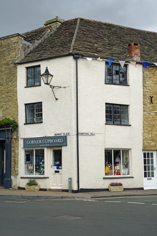
Entry Name: 17, Market Place
Listing Date: 21 March 1985
Grade: II
Source: Historic England
Source ID: 1341216
English Heritage Legacy ID: 128572
ID on this website: 101341216
Location: Tetbury, Cotswold, Gloucestershire, GL8
County: Gloucestershire
District: Cotswold
Civil Parish: Tetbury
Built-Up Area: Tetbury
Traditional County: Gloucestershire
Lieutenancy Area (Ceremonial County): Gloucestershire
Church of England Parish: Tetbury St Mary the Virgin
Church of England Diocese: Gloucester
Tagged with: Building
ST 8893-8993 TETBURY MARKET PLACE
(north side)
7/297 No 17
GV II
Corner house with ground floor shop. Early C18. Roughcast, hipped
Cotswold stone slate roof with small lateral brick stack. 3
storeys. 2 and 3-light leaded casements, 2-light to Market Place,
3-light to Gumstool Hill, on each floor, with shop window of C20 to
each side.
Listing NGR: ST8913293139
External links are from the relevant listing authority and, where applicable, Wikidata. Wikidata IDs may be related buildings as well as this specific building. If you want to add or update a link, you will need to do so by editing the Wikidata entry.


Other nearby listed buildings