Approximate Location Map
Large Map »
Latitude: 51.6379 / 51°38'16"N
Longitude: -2.3539 / 2°21'14"W
OS Eastings: 375601
OS Northings: 193296
OS Grid: ST756932
Mapcode National: GBR 0MD.CP6
Mapcode Global: VH95G.43X5
Plus Code: 9C3VJJQW+5C
Entry Name: The Tolsey
Listing Date: 23 June 1952
Last Amended: 16 August 1984
Grade: II
Source: Historic England
Source ID: 1341566
English Heritage Legacy ID: 128193
ID on this website: 101341566
Location: Wotton-under-Edge, Stroud, Gloucestershire, GL12
County: Gloucestershire
District: Stroud
Civil Parish: Wotton-under-Edge
Built-Up Area: Wotton-under-Edge
Traditional County: Gloucestershire
Lieutenancy Area (Ceremonial County): Gloucestershire
Church of England Parish: Wotton-under-Edge with Ozleworth
Church of England Diocese: Gloucester
Tagged with: Architectural structure
ST 7693
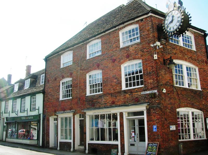
4/122 WOTTON-UNDER-EDGE MARKET STREET
23.6.52 (west)
No. 1 (The Tolsey)
(formerly listed as
No. 1 (Tolsey House))
GV
II
Offices, formerly Court House. C16 with C18 exterior. Brick, stone slate roof.
Rectangular block on important street corner, hipped roof with hexagonal painted wood
bell turret, stone stack. Three storeys, three windowed, sashes with glazing bars
under segmental heads; ground floor two small C19 shop fronts with pilasters one
glazed door with three-light fan over one old battened door with strap hinges. Facade
to High Street similar, one windowed, two-light sashes with bars; new plate glass shop
front.
Interior retains stone vaulted cellar in part; projecting stone newel stair to
basement solid oak treads upper floors; various heavy moulded beams with cavetto
and cyma to stops and diagonal 'dragon beam' at ground floor. Broad floor boards.
Heavy roof structure with collar and tie.
Listing NGR: ST7560193296
External links are from the relevant listing authority and, where applicable, Wikidata. Wikidata IDs may be related buildings as well as this specific building. If you want to add or update a link, you will need to do so by editing the Wikidata entry.


Other nearby listed buildings
