Approximate Location Map
Large Map »
Latitude: 51.9287 / 51°55'43"N
Longitude: -1.7159 / 1°42'57"W
OS Eastings: 419633
OS Northings: 225618
OS Grid: SP196256
Mapcode National: GBR 4Q2.507
Mapcode Global: VHBZ5.6SR9
Plus Code: 9C3WW7HM+FM
Entry Name: Enoch's Tower
Listing Date: 29 April 1983
Grade: II
Source: Historic England
Source ID: 1341616
English Heritage Legacy ID: 126343
ID on this website: 101341616
Location: Stow-on-the-Wold, Cotswold, Gloucestershire, GL54
County: Gloucestershire
District: Cotswold
Civil Parish: Stow-on-the-Wold
Built-Up Area: Stow-on-the-Wold
Traditional County: Gloucestershire
Lieutenancy Area (Ceremonial County): Gloucestershire
Church of England Parish: Stow-on-the Wold St Edward
Church of England Diocese: Gloucester
Tagged with: Tower
1.
5224 ODDINGTON ROAD
(north side)
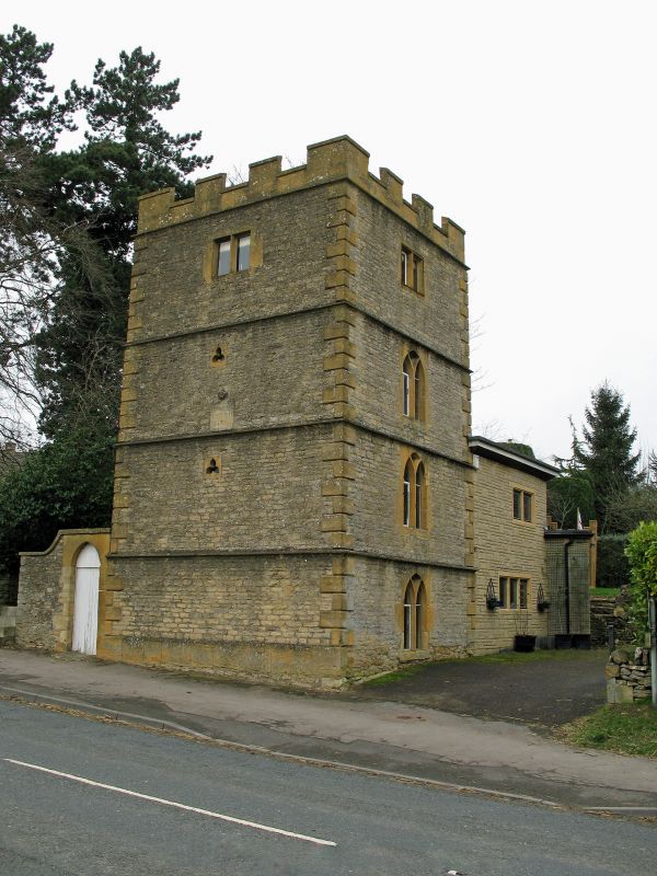
Enoch's Tower
SP 12 NE 1/79
II GV
2.
1848. Coursed rubble with quoins, projecting string courses at each floor and
battlemented parapet. Four storey 'folly' tower. Square. Pointed windows with
Y tracery, square headed on top floor. Modern house adjoins.
Listing NGR: SP1963325618
External links are from the relevant listing authority and, where applicable, Wikidata. Wikidata IDs may be related buildings as well as this specific building. If you want to add or update a link, you will need to do so by editing the Wikidata entry.


Other nearby listed buildings
