Approximate Location Map
Large Map »
Latitude: 51.7592 / 51°45'33"N
Longitude: -0.5613 / 0°33'40"W
OS Eastings: 499396
OS Northings: 207703
OS Grid: SP993077
Mapcode National: GBR F55.NXZ
Mapcode Global: VHFS4.714Q
Plus Code: 9C3XQC5Q+MF
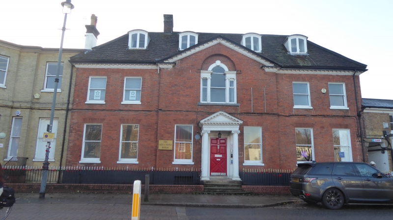
Entry Name: The Red House
Listing Date: 9 May 1973
Grade: II
Source: Historic England
Source ID: 1342177
English Heritage Legacy ID: 355457
ID on this website: 101342177
Location: Dacorum, Hertfordshire, HP4
County: Hertfordshire
District: Dacorum
Civil Parish: Berkhamsted
Built-Up Area: Berkhamsted
Traditional County: Hertfordshire
Lieutenancy Area (Ceremonial County): Hertfordshire
Church of England Parish: Great Berkhamsted
Church of England Diocese: St.Albans
Tagged with: House
SP 9907I NW 1/23
839
HIGH STREET (South Side)
No 113 (The Red House)
II
C18 house of red brick with steeply pitched hipped roof. 3 storeys, dentil
and modillion wooden eaves cornice. 5 sashes in reveals under flat arches,
no glazing bars. Central Roman Ionic porch with entablature, modillion
cornice, pediment. 4 segmentally headed easement dormers.
Listing NGR: SP9939607703
External links are from the relevant listing authority and, where applicable, Wikidata. Wikidata IDs may be related buildings as well as this specific building. If you want to add or update a link, you will need to do so by editing the Wikidata entry.


Other nearby listed buildings
