Approximate Location Map
Large Map »
Latitude: 51.8176 / 51°49'3"N
Longitude: -0.6691 / 0°40'8"W
OS Eastings: 491834
OS Northings: 214057
OS Grid: SP918140
Mapcode National: GBR F47.ZMB
Mapcode Global: VHFRP.CK4Z
Plus Code: 9C3XR89J+29
Entry Name: Farmhouse at Startop Farm
Listing Date: 29 May 1986
Grade: II
Source: Historic England
Source ID: 1342233
English Heritage Legacy ID: 355769
ID on this website: 101342233
Location: Startop's End, Dacorum, Hertfordshire, HP23
County: Hertfordshire
District: Dacorum
Civil Parish: Tring Rural
Traditional County: Hertfordshire
Lieutenancy Area (Ceremonial County): Hertfordshire
Church of England Parish: Tring
Church of England Diocese: St.Albans
Tagged with: Farmhouse
TRING RURAL LOWER ICKNIELD WAY
SP 91 SW
(North side)
Startop's End
4/132 Farmhouse at
- Startop Farm
- II
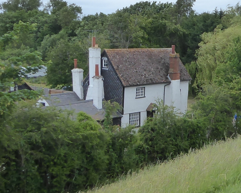
Farmhouse. Early C16 crosswing of hall house formerly extending to N,
converted to separate house with N catslide outshut in C17 or C18, C19
single storey W extension. Timber frame roughcast over black painted
plinth. Red tilehanging to W end. Painted brick ground floor on S. Steep
red tiled roof. Dark weatherboarded W extension with slate roof. A
2-storeys and attic, 2-bays former crosswing with jetty at E end
underbuilt now a house facing S. Sash window to ground floor front with
9/9 panes. Boarded door to right with rectangular fanlight and flat hood
on brackets. Large projecting chimney to right of door with 2-flues
(rebuilt after accident in 1940's). Attic windows at gable ends. E gable
has decorative brackets to ends of wallplates. Frame exposed inside with
jowled and chamfered posts, collar and queen-strut trusses, clasped-
purlin roof with straight wind-braces. Straight tension braces and wall
framing on ground floor in N wall.
Listing NGR: SP9183414057
External links are from the relevant listing authority and, where applicable, Wikidata. Wikidata IDs may be related buildings as well as this specific building. If you want to add or update a link, you will need to do so by editing the Wikidata entry.


Other nearby listed buildings
