Approximate Location Map
Large Map »
Latitude: 52.6017 / 52°36'5"N
Longitude: -1.9132 / 1°54'47"W
OS Eastings: 405972
OS Northings: 300434
OS Grid: SK059004
Mapcode National: GBR 3D5.WMX
Mapcode Global: WHBFW.LV4W
Plus Code: 9C4WJ32P+MP
Entry Name: The Shrubbery
Listing Date: 11 August 1951
Last Amended: 31 July 1986
Grade: II
Source: Historic England
Source ID: 1343039
English Heritage Legacy ID: 219075
ID on this website: 101343039
Location: Aldridge, Walsall, West Midlands, WS9
County: Walsall
Electoral Ward/Division: Aldridge Central and South
Parish: Non Civil Parish
Built-Up Area: Aldridge
Traditional County: Staffordshire
Lieutenancy Area (Ceremonial County): West Midlands
Church of England Parish: Aldridge St Mary the Virgin
Church of England Diocese: Lichfield
Tagged with: Architectural structure
WALSALL MB ERDINGTON ROAD
SK OO SE
Aldridge
5/36
The Shrubbery (formerly listed
under Aldridge UD)
11.08.51
- II
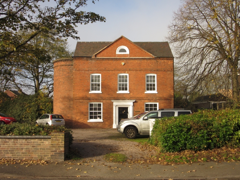
House, now used as offices. Mid- to late C18. Brick in Flemish bond
with tile roof. Facade symmetrical, of two storeys with attic and three
bays, with two string courses, and a dentil course at the eaves. Windows
sashed with glazing bars and segmental arches. Within a central pediment
is a lunette attic window. Door within doorcase of engaged Tuscan columns.
Return walls each have two gables. Left-hand wall of two bays, the right-
hand bay being a two-storey semi-circular brick bow with a window on both
floors.
Listing NGR: SK0597200434
External links are from the relevant listing authority and, where applicable, Wikidata. Wikidata IDs may be related buildings as well as this specific building. If you want to add or update a link, you will need to do so by editing the Wikidata entry.


Other nearby listed buildings
