Approximate Location Map
Large Map »
Latitude: 52.483 / 52°28'58"N
Longitude: -1.9012 / 1°54'4"W
OS Eastings: 406804
OS Northings: 287237
OS Grid: SP068872
Mapcode National: GBR 607.3S
Mapcode Global: VH9YX.0V7D
Plus Code: 9C4WF3MX+6G
Entry Name: Old Royal Public House
Listing Date: 8 July 1982
Grade: II
Source: Historic England
Source ID: 1343389
English Heritage Legacy ID: 216959
ID on this website: 101343389
Location: Birmingham, West Midlands, B3
County: Birmingham
Parish: Non Civil Parish
Built-Up Area: Birmingham
Traditional County: Warwickshire
Lieutenancy Area (Ceremonial County): West Midlands
Church of England Parish: Cathedral Church of St Philip Birmingham
Church of England Diocese: Birmingham
Tagged with: Pub
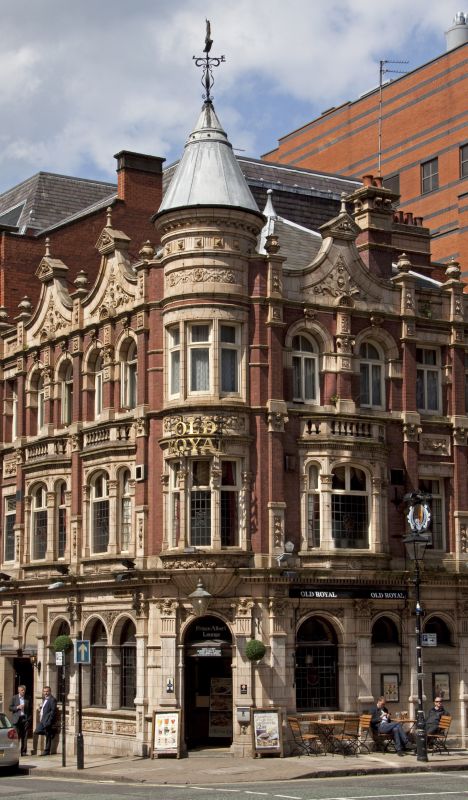
CHURCH STREET
1.
5104
City Centre B3
Nos 53 and 55
(Old Royal Public House)
SP 0687 SE 29/4
II GV
2.
Late C19. Purple brick and terracotta. In a vaguely Loire style. Three storeys;
2 1/2 bays plus the corner entrance bay with toarelle capped by an apparently altered
conical roof with lively weathervane and 3 1/2 bays on the right-hand return in
Cornwall Street. The bays are divided from one another by pilasters. Ground floor
arcuated. First floor with plain rectangular casements and shallow canted bay
windows with arched lights and carrying balconies. Second floor windows with plain
casements as on the 1st floor and, beneath the steep Dutch gables, couplets of
arched window. Everywhere busy decoration with garlands, foliage and cartouches.
Listing NGR: SP0680487237
External links are from the relevant listing authority and, where applicable, Wikidata. Wikidata IDs may be related buildings as well as this specific building. If you want to add or update a link, you will need to do so by editing the Wikidata entry.


Other nearby listed buildings
