Approximate Location Map
Large Map »
Latitude: 52.2102 / 52°12'36"N
Longitude: 0.1157 / 0°6'56"E
OS Eastings: 544656
OS Northings: 258994
OS Grid: TL446589
Mapcode National: GBR L79.D29
Mapcode Global: VHHK2.YQJ1
Plus Code: 9F426468+37
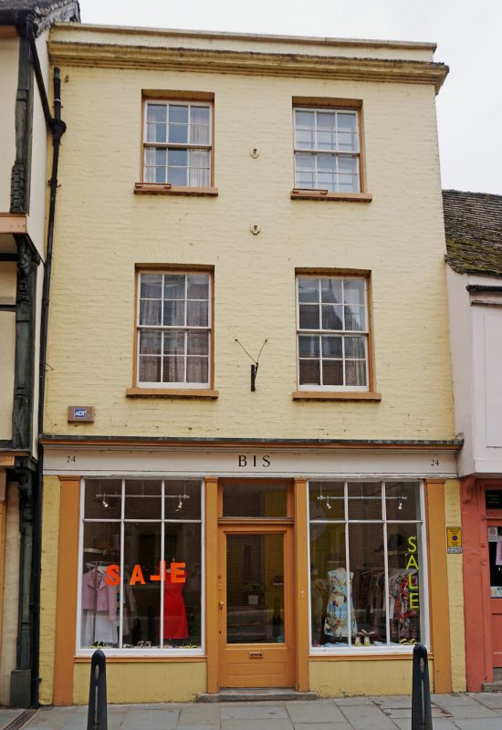
Entry Name: 24, Magdalene Street
Listing Date: 29 March 1962
Grade: II
Source: Historic England
Source ID: 1347908
English Heritage Legacy ID: 47579
ID on this website: 101347908
Location: Cambridge, Cambridgeshire, CB3
County: Cambridgeshire
District: Cambridge
Electoral Ward/Division: Castle
Parish: Non Civil Parish
Built-Up Area: Cambridge
Traditional County: Cambridgeshire
Lieutenancy Area (Ceremonial County): Cambridgeshire
Church of England Parish: Cambridge The Ascension
Church of England Diocese: Ely
Tagged with: Building
MAGDALENE STREET
1.
942
(South-west Side)
No 24
TL 4458 NE 3/92 29.3.62.
II GV
2.
Early C19 front or earlier building. 3 storeys, painted gault brick; moulded
cornice below low parapet; 2 windows, flat architraves glazing bars. Modern
shop front.
Nos 13 to 18 (consec) and Nos 20 to 31 (consec) form a group.
Listing NGR: TL4465658994
External links are from the relevant listing authority and, where applicable, Wikidata. Wikidata IDs may be related buildings as well as this specific building. If you want to add or update a link, you will need to do so by editing the Wikidata entry.


Other nearby listed buildings
