Latitude: 51.9464 / 51°56'47"N
Longitude: -0.087 / 0°5'13"W
OS Eastings: 531576
OS Northings: 229274
OS Grid: TL315292
Mapcode National: GBR K8S.W9X
Mapcode Global: VHGNW.FBVQ
Plus Code: 9C3XWWW7+H5
Entry Name: Paddocks Wells
Listing Date: 6 July 1984
Grade: II
Source: Historic England
Source ID: 1348013
English Heritage Legacy ID: 159840
ID on this website: 101348013
Location: Cottered, East Hertfordshire, SG9
County: Hertfordshire
District: East Hertfordshire
Civil Parish: Cottered
Built-Up Area: Cottered
Traditional County: Hertfordshire
Lieutenancy Area (Ceremonial County): Hertfordshire
Church of England Parish: Cottered with Broadfield
Church of England Diocese: St.Albans
Tagged with: Architectural structure Thatched cottage
TL 3129 COTTERED BALDOCK ROAD (south side)
5/11 Paddocks Wells
-
GV II
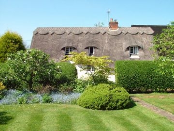
Almshouse now a house. Rebuilt on new site 1691 as part of Page's Charity (Chuck (n.d.) 11). Small 1960s E extension Timber frame roughcast with basketwork pargetting at ends, under a steep thatched roof. A long one and a half storeys house facing N with a rear outshut under a catslide roof. 4-cells with central chimney and lobby entry between the two E rooms. Low front eaves with 3 2-light flush casement windows and panelled door opposite red brick central chimney. Dripboard across each gable with 2-light window below and to attic above. Interior has thin timbers with tension bracing, axial beams with exposed joists, ogee stop to lintol of open fireplace with 2 recesses in the backwall over arch, clasped-purlin roof structure on collar- beam trusses, and axial joists of 2nd room removed to throw it open to the roof. Formerly called Nottinghams.
Listing NGR: TL3157629274
External links are from the relevant listing authority and, where applicable, Wikidata. Wikidata IDs may be related buildings as well as this specific building. If you want to add or update a link, you will need to do so by editing the Wikidata entry.


Other nearby listed buildings