Approximate Location Map
Large Map »
Latitude: 51.9085 / 51°54'30"N
Longitude: -2.54 / 2°32'23"W
OS Eastings: 362949
OS Northings: 223464
OS Grid: SO629234
Mapcode National: GBR FT.PW0Y
Mapcode Global: VH86J.X9K9
Plus Code: 9C3VWF56+92
Entry Name: Milestone
Listing Date: 17 March 1987
Grade: II
Source: Historic England
Source ID: 1348867
English Heritage Legacy ID: 155519
ID on this website: 101348867
Location: Weston under Penyard, County of Herefordshire, HR9
County: County of Herefordshire
Civil Parish: Weston under Penyard
Built-Up Area: Weston under Penyard
Traditional County: Herefordshire
Lieutenancy Area (Ceremonial County): Herefordshire
Church of England Parish: Weston under Penyard
Church of England Diocese: Hereford
Tagged with: Milestone
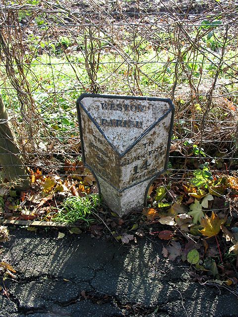
WESTON UNDER PENYARD CP A 40
SO 62 SW
5/103 Milestone
II
Milestone. Mid-C19. Cast iron. Triangular plan with sloping top inscribed:
"WESTON PARISH". Left-hand face inscribed: "TO ROSS 2 MILES". Right-hand
face inscribed: "TO GLOUCESTER 14 MILES".
Listing NGR: SO6294923464
External links are from the relevant listing authority and, where applicable, Wikidata. Wikidata IDs may be related buildings as well as this specific building. If you want to add or update a link, you will need to do so by editing the Wikidata entry.


Other nearby listed buildings
