Approximate Location Map
Large Map »
Latitude: 51.1023 / 51°6'8"N
Longitude: 0.3932 / 0°23'35"E
OS Eastings: 567651
OS Northings: 136388
OS Grid: TQ676363
Mapcode National: GBR NRN.XXN
Mapcode Global: VHJN3.RKQB
Plus Code: 9F32492V+W7
Entry Name: The Charity
Listing Date: 10 October 1989
Grade: II
Source: Historic England
Source ID: 1349065
English Heritage Legacy ID: 170055
ID on this website: 101349065
Location: Lamberhurst, Tunbridge Wells, Kent, TN3
County: Kent
District: Tunbridge Wells
Civil Parish: Lamberhurst
Built-Up Area: Lamberhurst
Traditional County: Kent
Lieutenancy Area (Ceremonial County): Kent
Church of England Parish: Lamberhurst St Mary
Church of England Diocese: Rochester
Tagged with: Architectural structure
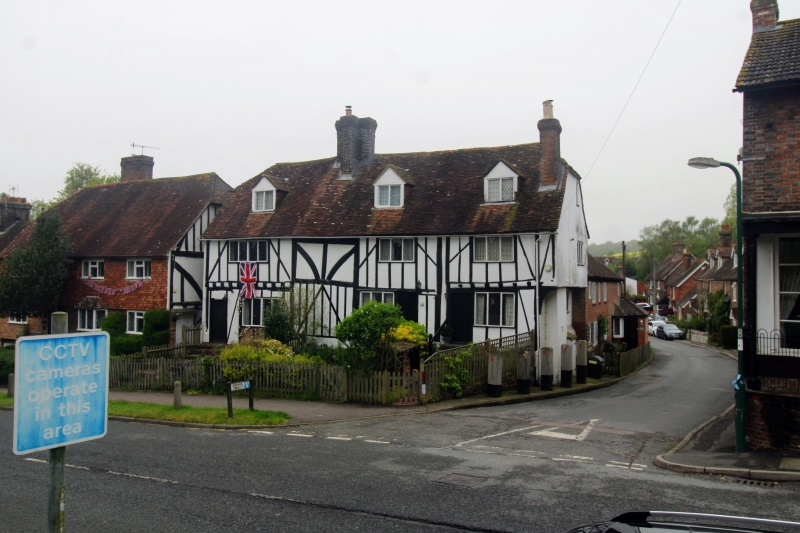
LAMBERHURST SCHOOL HILL
TQ 6636-6736
(west side)
8/218 Nos. 1, 2 & 3 The Charity
GV II
House, now house row. C15, altered and extended C16 and early C18, reconditioned
late C20. Timber framed and exposed with plaster infill and with plain tiled roof.
Wealden plan of four framed bays in origin. Two storeys, basement and attic on
plinth with underbuilt jetties to left and right end bays, with surviving jetty
returned to right on dragon post. Half-hipped roof with 3 gabled dormers and stack
to end right and large stack churner to centre left. Four light and 2 three light
C20 casements on each floor and rib and stud doors to left, centre right and right.
Basement opening in right return in high plinth. The right end bay is separately
framed and possibly added when the hall was ceiled over, indicated by a panel of
tension braced framing to upper left. the rest of the framing, now inappropriately
exposed, is late in character and meant only as a ground to the destroyed rendered
and sashed facade described in the old provisional list. The building was formerly
used as the village workhouse.
Listing NGR: TQ6765136388
External links are from the relevant listing authority and, where applicable, Wikidata. Wikidata IDs may be related buildings as well as this specific building. If you want to add or update a link, you will need to do so by editing the Wikidata entry.


Other nearby listed buildings
