Approximate Location Map
Large Map »
Latitude: 51.3893 / 51°23'21"N
Longitude: 1.3806 / 1°22'50"E
OS Eastings: 635300
OS Northings: 171011
OS Grid: TR353710
Mapcode National: GBR WZS.V5H
Mapcode Global: VHLG6.WB7S
Plus Code: 9F3399QJ+P7
Entry Name: Ingoldsby House
Listing Date: 22 February 1973
Grade: II
Source: Historic England
Source ID: 1351080
English Heritage Legacy ID: 356652
ID on this website: 101351080
Location: Margate, Thanet, Kent, CT9
County: Kent
District: Thanet
Electoral Ward/Division: Margate Central
Parish: Non Civil Parish
Built-Up Area: Margate
Traditional County: Kent
Lieutenancy Area (Ceremonial County): Kent
Tagged with: House
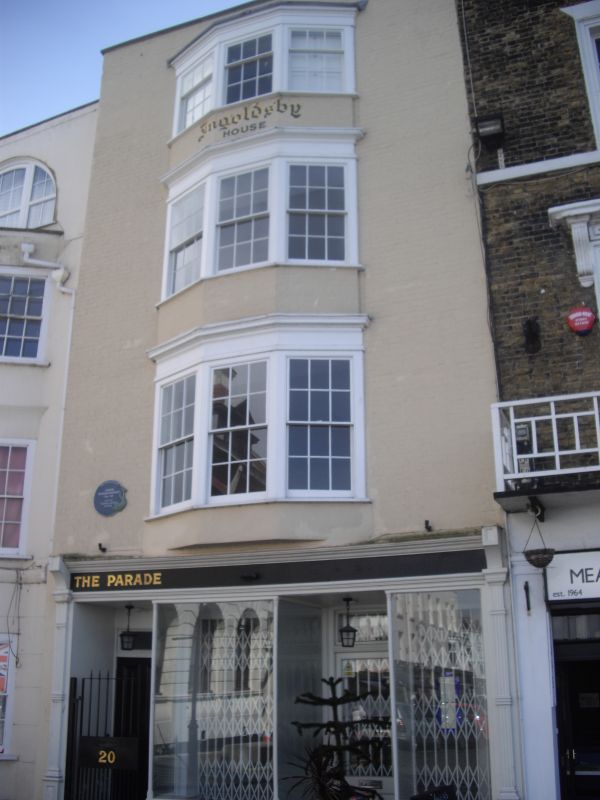
THE PARADE
1.
1380
No 20
(Ingoldsby House)
TR 3571 SW 2/256
II GV
2.
Early C19. 4 storeys painted brick. Tiled roof. Parapet. 3 light canted
bay through all floors. Later shopfront. The rear elevation has traces of
flintwork.
Nos 19 to 22 (consec) and No 1 High Street form a group
Listing NGR: TR3530071011
External links are from the relevant listing authority and, where applicable, Wikidata. Wikidata IDs may be related buildings as well as this specific building. If you want to add or update a link, you will need to do so by editing the Wikidata entry.


Other nearby listed buildings
