Approximate Location Map
Large Map »
Latitude: 52.0381 / 52°2'17"N
Longitude: 0.7269 / 0°43'36"E
OS Eastings: 587127
OS Northings: 241256
OS Grid: TL871412
Mapcode National: GBR QHJ.4LL
Mapcode Global: VHKF9.K14D
Plus Code: 9F422PQG+6Q
Entry Name: Karl Lindekam
Listing Date: 26 October 1971
Grade: II
Source: Historic England
Source ID: 1351360
English Heritage Legacy ID: 276042
ID on this website: 101351360
Location: Sudbury, Babergh, Suffolk, CO10
County: Suffolk
District: Babergh
Civil Parish: Sudbury
Built-Up Area: Sudbury
Traditional County: Suffolk
Lieutenancy Area (Ceremonial County): Suffolk
Church of England Parish: Sudbury St Gregory with Chilton St Peter
Church of England Diocese: St.Edmundsbury and Ipswich
Tagged with: Architectural structure
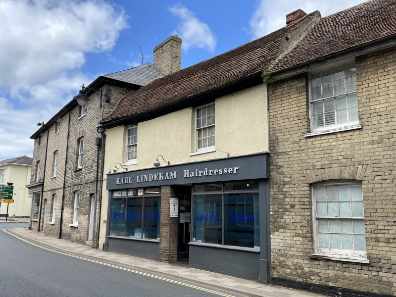
1. GAISBOROUGH STREET
1692
(North Side)
No 31 (Karl Lindekam)
TL 8741 3/177
II GV
2.
C18 with alterations. 2 storey 2 windows at 1st floor, recessed sash with
glazing bars. Tile mansard. Front stippled rendering. Plaster cove eaves
cornice. Ground floor modern shop front. Included for Group Value.
Nos 28 to 38 (consec) form a group.
Listing NGR: TL8712741256
External links are from the relevant listing authority and, where applicable, Wikidata. Wikidata IDs may be related buildings as well as this specific building. If you want to add or update a link, you will need to do so by editing the Wikidata entry.


Other nearby listed buildings
