Approximate Location Map
Large Map »
Latitude: 51.0597 / 51°3'35"N
Longitude: -0.3309 / 0°19'51"W
OS Eastings: 517065
OS Northings: 130259
OS Grid: TQ170302
Mapcode National: GBR HJN.F61
Mapcode Global: FRA B66B.0WJ
Plus Code: 9C3X3M59+VJ
Entry Name: Parish Church of St Mary
Listing Date: 20 May 1949
Grade: I
Source: Historic England
Source ID: 1353908
English Heritage Legacy ID: 298126
ID on this website: 101353908
Location: St Mary's Church, Horsham, West Sussex, RH12
County: West Sussex
District: Horsham
Electoral Ward/Division: Denne
Parish: Non Civil Parish
Built-Up Area: Horsham
Traditional County: Sussex
Lieutenancy Area (Ceremonial County): West Sussex
Church of England Parish: Horsham St Mary the Virgin
Church of England Diocese: Chichester
Tagged with: Church building
THE CAUSEWAY
1. (East Side)
1236 Parish Church of
St Mary
TQ 1730 1/12 20.5.49.
GV I
2.
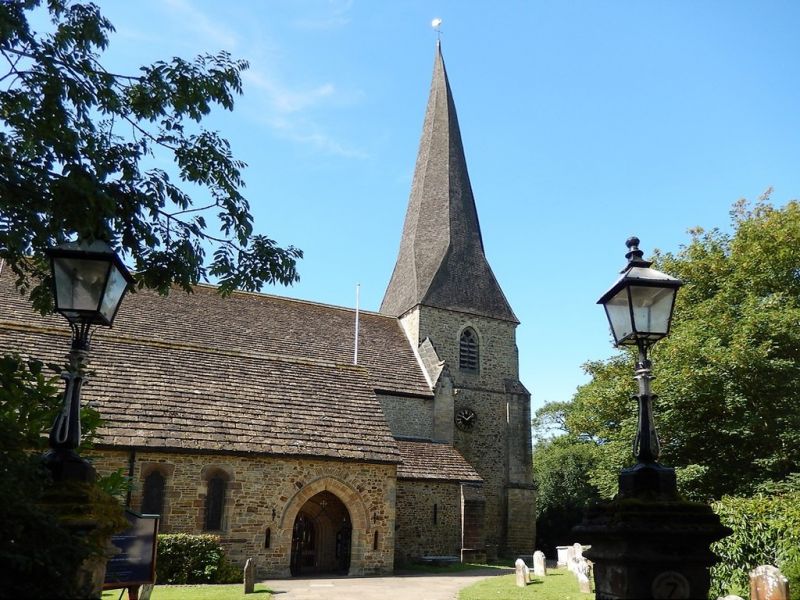
Large C13 church, heavily restored by Teulon. Tall shingled spire to west tower.
The Vestry, called the Lollards' Tower, at north-east corner, is C15.
All the listed buildings in the Causeway form a very important group with all the listed buildings in Market Square and with South Street.
Listing NGR: TQ1706530257
External links are from the relevant listing authority and, where applicable, Wikidata. Wikidata IDs may be related buildings as well as this specific building. If you want to add or update a link, you will need to do so by editing the Wikidata entry.


Other nearby listed buildings
