Approximate Location Map
Large Map »
Latitude: 51.0608 / 51°3'38"N
Longitude: -0.33 / 0°19'47"W
OS Eastings: 517127
OS Northings: 130377
OS Grid: TQ171303
Mapcode National: GBR HJN.FD8
Mapcode Global: FRA B669.TH3
Plus Code: 9C3X3M6C+82
Entry Name: The Minstrel
Listing Date: 17 March 1952
Grade: II
Source: Historic England
Source ID: 1027547
English Heritage Legacy ID: 298131
ID on this website: 101027547
Location: Horsham, West Sussex, RH12
County: West Sussex
District: Horsham
Electoral Ward/Division: Denne
Parish: Non Civil Parish
Built-Up Area: Horsham
Traditional County: Sussex
Lieutenancy Area (Ceremonial County): West Sussex
Church of England Parish: Horsham St Mary the Virgin
Church of England Diocese: Chichester
Tagged with: Building
1.
1236
TQ 1730
1/16
17.3.52
THE CAUSEWAY
(West Side)
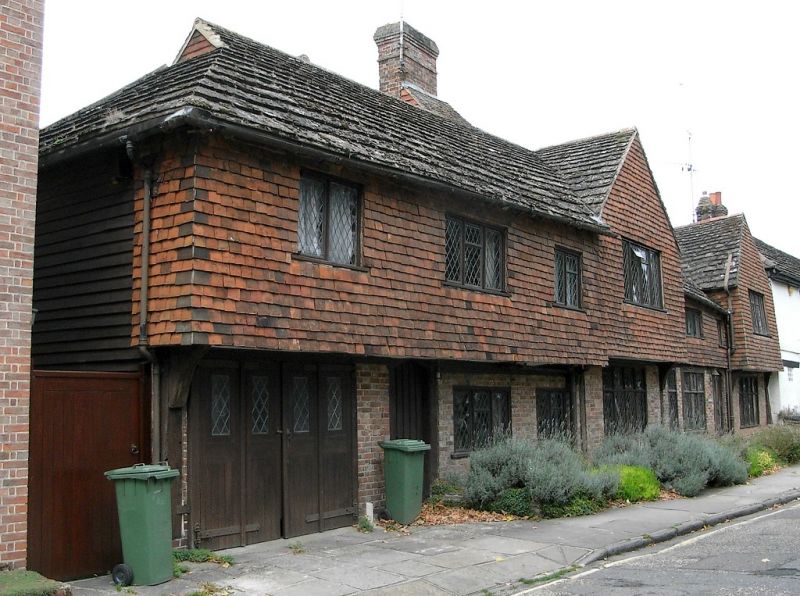
Nos 29 & 30 (The Minstrel)
II
GV
2.
This was previously timber-framed cottages, but in modern times has been converted
into two houses and refronted with red brick on the ground floor and tiles above.
The overhang of the 1st floor on curved brackets and the Horsham slab roof of the
old house have been preserved. 2 gables. 2 storeys. 7 windows. All windows
modern casements with diamond leaded lights.
The Manor House, Stables to the south and Nos 24 to 31 (consec) form a group with
Nos 1 to 7 (odd) Blackhorse Way and with all the listed buildings in South Street.
All the listed buildings in The Causeway form a very important group with all the
listed buildings in Market Square and with South Street.
Listing NGR: TQ1712730377
External links are from the relevant listing authority and, where applicable, Wikidata. Wikidata IDs may be related buildings as well as this specific building. If you want to add or update a link, you will need to do so by editing the Wikidata entry.


Other nearby listed buildings
