Approximate Location Map
Large Map »
Latitude: 50.4708 / 50°28'14"N
Longitude: -4.7185 / 4°43'6"W
OS Eastings: 207185
OS Northings: 66976
OS Grid: SX071669
Mapcode National: GBR N2.MRST
Mapcode Global: FRA 170T.7KR
Plus Code: 9C2QF7CJ+8H
Entry Name: 3, Mount Folly Square
Listing Date: 7 January 1994
Grade: II
Source: Historic England
Source ID: 1355149
English Heritage Legacy ID: 368030
ID on this website: 101355149
Location: Bodmin, Cornwall, PL31
County: Cornwall
Civil Parish: Bodmin
Built-Up Area: Bodmin
Traditional County: Cornwall
Lieutenancy Area (Ceremonial County): Cornwall
Church of England Parish: Bodmin
Church of England Diocese: Truro
Tagged with: Building
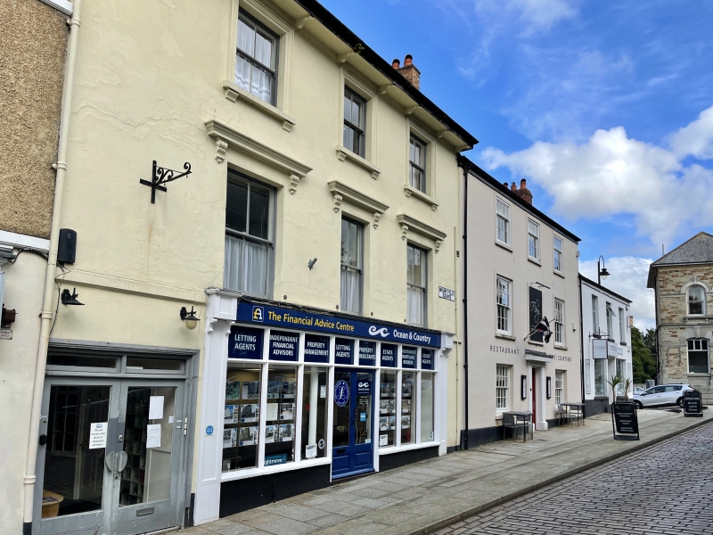
BODMIN
SX0666 MOUNT FOLLY SQUARE
629-1/3/89 (North side)
No.3
GV II
Town house with later shop. Mid C19 or possibly a mid C19
remodelling of an older house. Stucco on rubble;
bitumen-grouted slate roof with projecting front eaves on
widely-spaced brackets; slatehanging to visible right-hand
end; brick axial stacks towards left and right and shared end
brick stacks. Double-depth plan. 3 storeys; 3-window range.
Late C19 four-pane horned sashes; moulded hoods on brackets to
1st floor, moulded architraves and sills on brackets to 2nd
floor. Ground floor has mid C20 double shop front; house
doorway on left with overlight. INTERIOR: not inspected.
Listing NGR: SX0718566976
External links are from the relevant listing authority and, where applicable, Wikidata. Wikidata IDs may be related buildings as well as this specific building. If you want to add or update a link, you will need to do so by editing the Wikidata entry.


Other nearby listed buildings
