Approximate Location Map
Large Map »
Latitude: 54.9675 / 54°58'2"N
Longitude: -1.6175 / 1°37'3"W
OS Eastings: 424584
OS Northings: 563718
OS Grid: NZ245637
Mapcode National: GBR SNP.PZ
Mapcode Global: WHC3R.4D0P
Plus Code: 9C6WX98J+XX
Entry Name: Water Tower South of Central Station
Listing Date: 30 March 1987
Grade: II
Source: Historic England
Source ID: 1355257
English Heritage Legacy ID: 304558
ID on this website: 101355257
Location: Newcastle Helix, Newcastle upon Tyne, Tyne and Wear, NE1
County: Newcastle upon Tyne
Electoral Ward/Division: Westgate
Parish: Non Civil Parish
Built-Up Area: Newcastle upon Tyne
Traditional County: Northumberland
Lieutenancy Area (Ceremonial County): Tyne and Wear
Church of England Parish: St Nicholas Newcastle-upon-Tyne
Church of England Diocese: Newcastle
Tagged with: Water tower
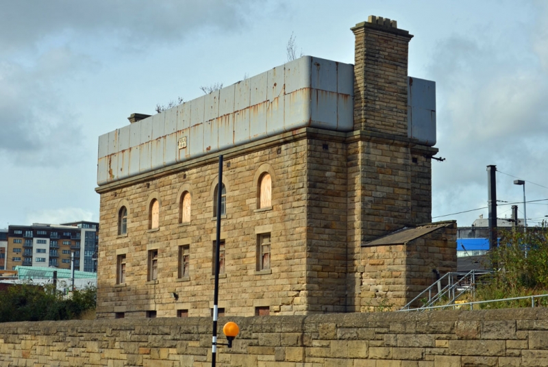
NZ 2463 NE NEWCASTLE UPON TYNE FORTH STREET
(north side)
23/246 Water tower south of
Central Station.
G.V. II
Water tower. Dated on plaque on tank NER/1891; for North Eastern Railway.
Rockfaced sandstone with ashlar dressings; iron tank. 3 storeys, 5 bays and
tank on top. Flat stone lintels and slightly projecting stone sills to
mullioned-and-transomed windows on ground and first floors; similar sills to
round-headed second-floor windows under stone arches. Moulded cornice, Chimney
stacks on returns and high corniced chimneys, square yellow pots to that at
right. Tank about 2m high and of same dimensions as building.
Listing NGR: NZ2458463718
External links are from the relevant listing authority and, where applicable, Wikidata. Wikidata IDs may be related buildings as well as this specific building. If you want to add or update a link, you will need to do so by editing the Wikidata entry.


Other nearby listed buildings
