Approximate Location Map
Large Map »
Latitude: 51.2178 / 51°13'4"N
Longitude: 0.5325 / 0°31'57"E
OS Eastings: 576961
OS Northings: 149558
OS Grid: TQ769495
Mapcode National: GBR PRT.PF5
Mapcode Global: VHJMM.5NW9
Plus Code: 9F326G9M+42
Entry Name: Church Farm House
Listing Date: 23 May 1967
Grade: II
Source: Historic England
Source ID: 1356183
English Heritage Legacy ID: 174485
ID on this website: 101356183
Location: Maidstone, Kent, ME17
County: Kent
District: Maidstone
Civil Parish: Boughton Monchelsea
Traditional County: Kent
Lieutenancy Area (Ceremonial County): Kent
Tagged with: Farmhouse
BOUGHTON MONCHELSEA CHURCH HILL
TQ 74 NE (West side)
2/24 Church Farm House
23.5.67
GV II
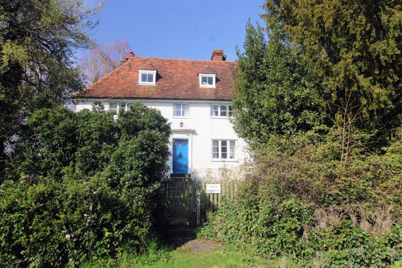
Farmhouse, now house. C18 or earlier, with early-to-mid C19 facade. Channelled
render with plain tile roof. 2 storeys, attics and cellar. High painted brick
plinth on painted stone base. Boxed eaves. Roof hipped to left, half-hipped
to right, with gablets. Rear stack to left, rear stack to right of centre,
and slightly projecting stack to right gable end. 3 small hipped dormers.
Irregular fenestration of 4 casements; three 3-light, and one 2-light over
door. Panelled door with 2 top lights in reeded architrave with paterae,
plain frieze, and shallow moulded hood, up 4 steps under second window from
left. Short rear return wing to right, with half-hipped plain-tile roof.
Rear lean-to to left. Interior not inspected.
Listing NGR: TQ7696149558
External links are from the relevant listing authority and, where applicable, Wikidata. Wikidata IDs may be related buildings as well as this specific building. If you want to add or update a link, you will need to do so by editing the Wikidata entry.


Other nearby listed buildings
