Approximate Location Map
Large Map »
Latitude: 53.5289 / 53°31'44"N
Longitude: -2.2871 / 2°17'13"W
OS Eastings: 381065
OS Northings: 403624
OS Grid: SD810036
Mapcode National: GBR DWGM.NP
Mapcode Global: WH983.VK2H
Plus Code: 9C5VGPH7+H5
Entry Name: Gate Piers and Boundary Walls to Churchyard Of St Mary
Listing Date: 29 January 1985
Last Amended: 21 February 2012
Grade: II
Source: Historic England
Source ID: 1356815
English Heritage Legacy ID: 210622
ID on this website: 101356815
Location: St Mary's Church, Prestwich, Bury, Greater Manchester, M25
County: Bury
Electoral Ward/Division: St Mary's
Parish: Non Civil Parish
Built-Up Area: Manchester
Traditional County: Lancashire
Lieutenancy Area (Ceremonial County): Greater Manchester
Church of England Parish: Prestwich St Mary
Church of England Diocese: Manchester
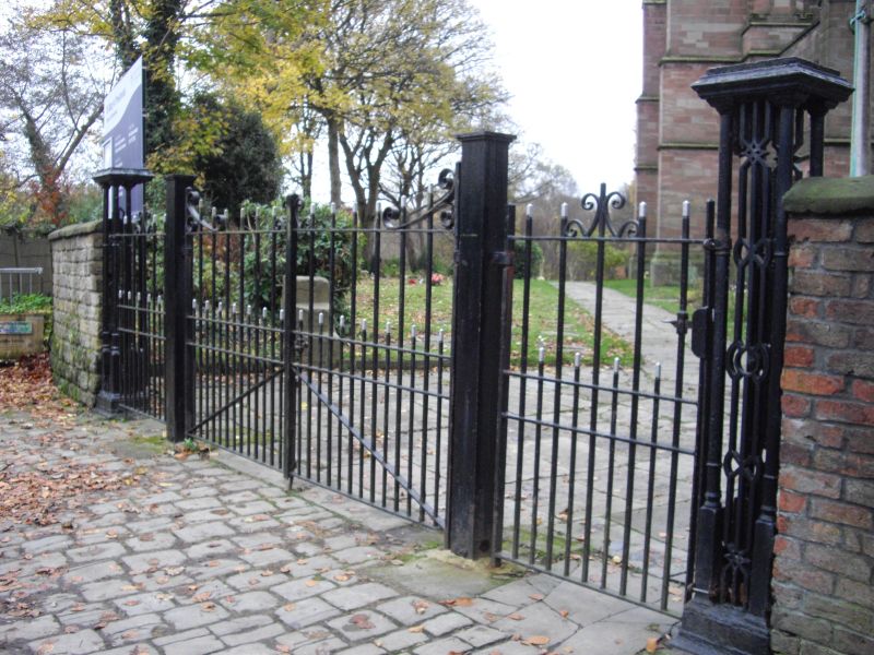
Gate piers of c1827 and boundary walls of 1827 and 1886 enclosing St Mary's churchyard to north, east and south sides.
North, east and south boundary walls (1827) constructed of coursed sandstone with curved copings, original iron railings now removed to north and south walls; some post WWII railings survive to east wall. North wall abuts the C18 Church Inn (also listed at Grade II). Later section of boundary wall to south of 1827 south wall erected in 1886 when the graveyard was enlarged; wall is of coursed sandstone with large, square carved blocks for copings with tool mark decoration. Openwork cast-iron gate piers set to north-east corner of churchyard with flat tops, colonettes to corners and latticework in between. C20 double and single gates between piers are not included in the listing. Gate piers flanked to south by raised section of east boundary wall. Section of red brick wall (1827) of same height with sandstone copings is attached to north side of gate piers and extends to Church Inn. West face of wall incorporates a large stone containing an incised oval shape and inscription dated 1827 that records the extending of the churchyard and its enclosure.
St Mary's Church, Prestwich, dates to the C14 with later alterations, and the oldest extant grave marker in the churchyard dates to 1641. However, the topography of the churchyard suggests a much older burial ground. The churchyard has been extended many times, including in 1827 when boundary walls were constructed. Prior to these walls being erected the churchyard was enclosed by a ditch and hedge created in 1706, and subsequently by the planting of beech and fir trees in 1763. Further extensions to the churchyard occurred in 1864, 1886, 1924 and 1950.
The western section of the churchyard contains, amongst other graves, the unmarked burials of thousands of inmates of the County Asylum Prestwich dating from the mid-C19 to early-C20, although several communal graves for the asylum's attendants and some inmates are marked by grave slabs. In 1801 a hearse house (altered in the mid-late C20) was constructed to the north of the church.
The boundary walls and entrance gate piers of St Mary's churchyard, Prestwich, are designated at Grade II for the following principal reasons:
* Historic interest: They illustrate the extensive history of the St Mary's churchyard and its expansion during the C19
* Group value: They have group value with the Grade I listed St Mary's Church and the other listed monuments and structures in the St Mary's churchyard
External links are from the relevant listing authority and, where applicable, Wikidata. Wikidata IDs may be related buildings as well as this specific building. If you want to add or update a link, you will need to do so by editing the Wikidata entry.


Other nearby listed buildings
