Approximate Location Map
Large Map »
Latitude: 51.3594 / 51°21'33"N
Longitude: -0.2172 / 0°13'1"W
OS Eastings: 524224
OS Northings: 163766
OS Grid: TQ242637
Mapcode National: GBR BR.3X7
Mapcode Global: VHGRQ.6317
Plus Code: 9C3X9Q5M+Q4
Entry Name: Whitehall
Listing Date: 28 August 1953
Grade: II*
Source: Historic England
Source ID: 1357580
English Heritage Legacy ID: 206748
Also known as: Whitehall Historic House
Whitehall, Cheam
ID on this website: 101357580
Location: Cheam, Sutton, London, SM3
County: London
District: Sutton
Electoral Ward/Division: Cheam
Parish: Non Civil Parish
Built-Up Area: Sutton
Traditional County: Surrey
Lieutenancy Area (Ceremonial County): Greater London
Church of England Parish: Cheam
Church of England Diocese: Southwark
Tagged with: Historic house museum Local authority museum Independent museum
MALDEN ROAD
1.
4430
(South-West Side)
CHEAM
No 1 (Whitehall)
TQ 2463 NW 29/99 28.8.53.
II* GV
2.
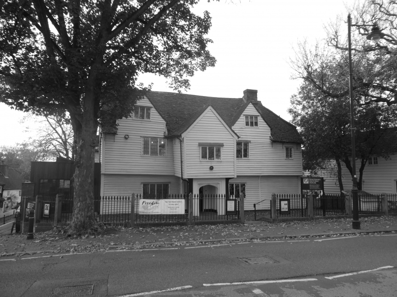
Circa 1500 continuous jetty house with crown-post roof and possibly with fireplace
and chimney from the beginning. C18 painted weatherboarding covering close-studded
framing. Probably later C16 to early C17 addition of porch, newel stair and
attics; C17 addition of 2 rooms to rear. 2 storeys and attic. The 2 storey projecting
gabled porch with old 3-light leaded window to 1st floor, and entrance on ground
floor with moulded oak 4-centred headed archway. The sides of the porch are also
open and there is a 4-centred headed moulded doorway. Old leaded windows with
diamond and hexagonal panes; 4-light to ground floor [one each side of porch],
and similarly to 1st floor, a small 2-light window further right. 2 gabled attics
in carry-up of wall each with 3-light windows. Old tile roof hipped to right
with gablet; plain stacks. Rear elevation has projecting gabled wing on left
with French window to ground floor, sash window to 1st floor and 3-light casement
to apex of gable. Central small projection staircase "tower" with small casements
and gabled roof. Wing to right has roof parallel to same range, 2 storeys, various
windows [See article by K Gravett in Surrey Archaeological Journal, 1966].
Nos 1 to 9 (odd) Malden Road, garden wall to north of Nos 1 and 3 Malden Road,
Rectory, garden walls and laundry in grounds of Rectory form a group with
Nos 45 to 57 (odd) The Broadway, and with Nos 1 to 25 (odd) Park Lane.
Listing NGR: TQ2422463766
External links are from the relevant listing authority and, where applicable, Wikidata. Wikidata IDs may be related buildings as well as this specific building. If you want to add or update a link, you will need to do so by editing the Wikidata entry.


Other nearby listed buildings
