Approximate Location Map
Large Map »
Latitude: 51.4953 / 51°29'43"N
Longitude: -0.1559 / 0°9'21"W
OS Eastings: 528109
OS Northings: 178985
OS Grid: TQ281789
Mapcode National: GBR 9L.54
Mapcode Global: VHGQZ.7PX2
Plus Code: 9C3XFRWV+4J
Entry Name: 89 and 91, Eaton Place SW1
Listing Date: 15 April 1969
Grade: II
Source: Historic England
Source ID: 1358145
English Heritage Legacy ID: 203760
ID on this website: 101358145
Location: Belgravia, Kensington and Chelsea, London, SW1X
County: London
District: Kensington and Chelsea
Electoral Ward/Division: Brompton & Hans Town
Parish: Non Civil Parish
Built-Up Area: Kensington and Chelsea
Traditional County: Middlesex
Lieutenancy Area (Ceremonial County): Greater London
Church of England Parish: Holy Trinity Sloane Square
Church of England Diocese: London
Tagged with: Building
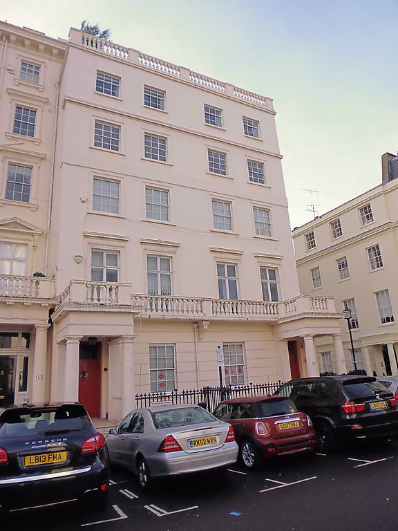
TQ 2878 NW EATON PLACE SW1
50/5
15.4.69 Nos 89 and 91
GV
II
Terrace of houses. Early to mid C19. Five storeys, stucco. Two sashes each. Ground floor rusticated with Doric porches and balustraded balcony. French windows on first floor with architraves and cornices. Second and third floor windows with architraves and cornice above third floor windows; plain sashes. Top floor windows with cornice. Open balustrde to parapet.
Listing NGR: TQ2810978985
External links are from the relevant listing authority and, where applicable, Wikidata. Wikidata IDs may be related buildings as well as this specific building. If you want to add or update a link, you will need to do so by editing the Wikidata entry.


Other nearby listed buildings
