Approximate Location Map
Large Map »
Latitude: 51.4101 / 51°24'36"N
Longitude: -0.3057 / 0°18'20"W
OS Eastings: 517929
OS Northings: 169262
OS Grid: TQ179692
Mapcode National: GBR 78.ZJ9
Mapcode Global: VHGR8.NT7C
Plus Code: 9C3XCM6V+3P
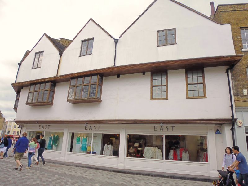
Entry Name: 23, Market Place
Listing Date: 30 July 1951
Grade: II
Source: Historic England
Source ID: 1358430
English Heritage Legacy ID: 203160
ID on this website: 101358430
Location: Kingston upon Thames, London, KT1
County: London
District: Kingston upon Thames
Electoral Ward/Division: Grove
Parish: Non Civil Parish
Built-Up Area: Kingston upon Thames
Traditional County: Surrey
Lieutenancy Area (Ceremonial County): Greater London
Church of England Parish: All Saints, Kingston-on-Thames
Church of England Diocese: Southwark
Tagged with: Building
Early C17 with C18 alterations. Much rebuilt after fire in 1973. Timber framed. Tiled pitched roof. Originally 2 storey range with jettied upper floor comprising 3 separate units. In the C18, the roof was raised to accommodate attics and rebuilt with four gabled dormers, though the original roof trusses were retained. The walls are rendered. On the ground floor is a shop front of similar design to the C19 shop front existing at the time of the fire. Much of the timber frame and facade survived the fire as did some C17 timber panelling on the 1st floor but the load-bearing function of the timber frame has now been taken over by a new reinforced concrete frame. Also known as No 1 Church Street.
Listing NGR: TQ1792969262
Kingston upon Thames, historically in Surrey, was an important market town, port and river crossing from the early medieval period, while there is evidence of Saxon settlement and of activity dating from the prehistoric period and of Roman occupation. It is close to the important historic royal estates at Hampton Court, Bushy Park, Richmond and Richmond Park. The old core of the town, around All Saints Church (C14 and C15, on an earlier site) and Market Place, with its recognisably medieval street pattern, is ‘the best preserved of its type in outer London’ (Pevsner and Cherry, London: South, 1983 p. 307). Kingston thrived first as an agricultural and market town and on its historic industries of malting, brewing and tanning, salmon fishing and timber exporting, before expanding rapidly as a suburb after the arrival of the railway in the 1860s. In the later C19 it become a centre of local government, and in the early C20 became an important shopping and commercial centre. Its rich diversity of buildings and structures from all periods reflect the multi-facetted development of the town.
External links are from the relevant listing authority and, where applicable, Wikidata. Wikidata IDs may be related buildings as well as this specific building. If you want to add or update a link, you will need to do so by editing the Wikidata entry.


Other nearby listed buildings
