Approximate Location Map
Large Map »
Latitude: 51.478 / 51°28'40"N
Longitude: -0.002 / 0°0'7"W
OS Eastings: 538847
OS Northings: 177336
OS Grid: TQ388773
Mapcode National: GBR L1.Q4J
Mapcode Global: VHGR7.X39V
Plus Code: 9C3XFXHX+55
Entry Name: Royal Observatory Flamsteed House
Listing Date: 8 June 1973
Grade: I
Source: Historic England
Source ID: 1358976
English Heritage Legacy ID: 200387
ID on this website: 101358976
Location: Greenwich Park, Greenwich, London, SE10
County: London
District: Greenwich
Electoral Ward/Division: Greenwich West
Parish: Non Civil Parish
Built-Up Area: Greenwich
Traditional County: Kent
Lieutenancy Area (Ceremonial County): Greater London
Church of England Parish: Greenwich St Alfege
Church of England Diocese: Southwark
Tagged with: Building
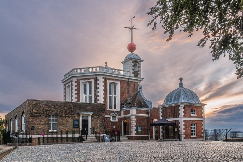
1.
4412 GREENWICH PARK SE10
Royal Observatory
Flamsteed House
TQ 3877 26/G54
I
2.
1675-6 with later additions, attributed to Sir Christopher Wren. Main North
front of 2 storeys. 3 window centre with square 3-storey angle towers. Projecting
eaves cornices and domed caps with high vanes to towers. Red brick with white
stone quoins, both to towers and to main building. Very tall 1st floor with
projecting cornice and balustrade over between towers. Very long plain central
window in chamfered stone architrave. Wrought iron balcony. Side windows in
moulded, shouldered architraves. Stone string at 1st floor level. 7-window
ground floor. Parapet with stone coping has scrolled ramped inner part sweeping
up almost to cornice of main block. Moulded architraves to ground floor windows.
Door at left opening to walled terrace blocked at either end by 2-storey, 1-window
C18 pavilions in similar style with domes. Rear elevation a large canted bay
with coved and moulded cornice and balustraded parapet. 1st floor only visible
as 1-storey C19 brick extension masks ground floor. Entrance on East, in angle
at right, has porch protection with roof sloping up to front parapet. Side and
rear windows very long casements in shouldered, moulded stone architraves. Beneath
East window a plaque in richly carved baroque stone frame with serpentine open
pediment, bears Latin inscription stating that Charles II founded the observatory
in 1676. Inside a staircase with barley-sugar twist columns leads to the octagon
room containing historic portraits, telescopes and clocks. Coved, octagonal
ceiling centre wth decorative border. Moulded and coved cornice with garlands
in high relief and royal ciphers. A later staircase leads down to the rear extension
now laid out as a museum of historic astronomical instruments.
Listing NGR: TQ3888877321
External links are from the relevant listing authority and, where applicable, Wikidata. Wikidata IDs may be related buildings as well as this specific building. If you want to add or update a link, you will need to do so by editing the Wikidata entry.


Other nearby listed buildings
