Approximate Location Map
Large Map »
Latitude: 51.3539 / 51°21'14"N
Longitude: 0.1378 / 0°8'16"E
OS Eastings: 548956
OS Northings: 163816
OS Grid: TQ489638
Mapcode National: GBR RB.HDN
Mapcode Global: VHHPC.B7PF
Plus Code: 9F32943Q+H4
Entry Name: Osbornes
Listing Date: 29 June 1973
Grade: II
Source: Historic England
Source ID: 1359298
English Heritage Legacy ID: 358529
ID on this website: 101359298
Location: Bopeep, Bromley, London, BR6
County: London
District: Bromley
Electoral Ward/Division: Chelsfield and Pratts Bottom
Parish: Non Civil Parish
Traditional County: Kent
Lieutenancy Area (Ceremonial County): Greater London
Church of England Parish: Chelsfield St Martin of Tours
Church of England Diocese: Rochester
Tagged with: Building
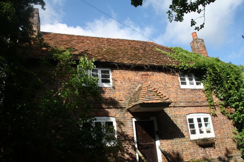
MAYPOLE ROAD, CHELSFIELD
1.
4407
Osbornes
TQ 46 SE 10/141
II
2.
Cottage dated 1705. 2 storeys. 2 windows. Red brick. Plinth and string-
course. Tiled roof. Casement windows. Modillion eaves cornice. Right
hand chimney stack. Doorway at the head of 7 steps to which a tiled canopy
has been added.
Listing NGR: TQ4895663816
External links are from the relevant listing authority and, where applicable, Wikidata. Wikidata IDs may be related buildings as well as this specific building. If you want to add or update a link, you will need to do so by editing the Wikidata entry.


Other nearby listed buildings
