Approximate Location Map
Large Map »
Latitude: 52.7879 / 52°47'16"N
Longitude: -0.1524 / 0°9'8"W
OS Eastings: 524693
OS Northings: 322743
OS Grid: TF246227
Mapcode National: GBR HX9.B8V
Mapcode Global: WHHMM.M6M2
Plus Code: 9C4XQRQX+42
Entry Name: 39, NEW ROAD (See details for further address information)
Listing Date: 20 November 1975
Grade: II
Source: Historic England
Source ID: 1359543
English Heritage Legacy ID: 197346
ID on this website: 101359543
Location: Spalding, South Holland, Lincolnshire, PE11
County: Lincolnshire
District: South Holland
Electoral Ward/Division: Spalding Castle
Parish: Non Civil Parish
Built-Up Area: Spalding
Traditional County: Lincolnshire
Lieutenancy Area (Ceremonial County): Lincolnshire
Church of England Parish: Spalding St Mary and St Nicolas
Church of England Diocese: Lincoln
Tagged with: Building
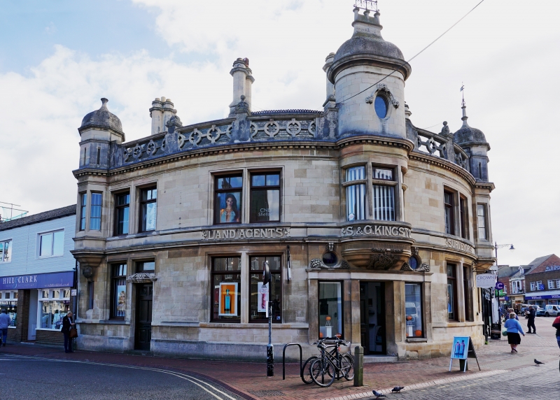
NEW ROAD
1.
5313
(South East Side)
No 39
TF 2421 1/212
II GV
2.
Includes No 24 Hall Place. Early C20. Modified Jacobean. 2 storeys in ashlar
with slate roof with ridge tile and pierced parapet with finials. Symmetrical
composition, curved to site, with oriels to ends with octagonal turret roofs
with parapets and leaded domed roofs with finials, lst floor has 6 paired windows
and central oriel with carved base below stone turret, oval in section with lion
weathervane and round window. Ground floor has 2 large windows and 2 narrow
lights with 2 round windows over, flanking doorway. Another doorway to the left,
and 1 window. Band between storeys bears legend 'Land Agents S & G Kingston
Surveyors'. The building also bears the dates 1828 and 1907.
A visual group with Cavendish House, opposite a local interest building and
No 24 Hall Place.
Listing NGR: TF2469322743
External links are from the relevant listing authority and, where applicable, Wikidata. Wikidata IDs may be related buildings as well as this specific building. If you want to add or update a link, you will need to do so by editing the Wikidata entry.


Other nearby listed buildings
