Latitude: 53.7243 / 53°43'27"N
Longitude: -2.5639 / 2°33'49"W
OS Eastings: 362891
OS Northings: 425465
OS Grid: SD628254
Mapcode National: GBR BTJC.QP
Mapcode Global: WH970.LNB8
Plus Code: 9C5VPCFP+PF
Entry Name: Barn Circa 40 Metres South of Causeway Farmhouse with Attached Pigsties
Listing Date: 30 January 1987
Grade: II
Source: Historic England
Source ID: 1362117
English Heritage Legacy ID: 184404
ID on this website: 101362117
Location: Riley Green, Chorley, Lancashire, PR5
County: Lancashire
District: Chorley
Civil Parish: Hoghton
Traditional County: Lancashire
Lieutenancy Area (Ceremonial County): Lancashire
Church of England Parish: Hoghton Holy Trinity
Church of England Diocese: Blackburn
Tagged with: Barn
HOGHTON RILEY GREEN SWITCH ROAD SD 62 NW 2/150 Barn c.40 metres south of Causeway Farmhouse, with - attached pigsties GV II
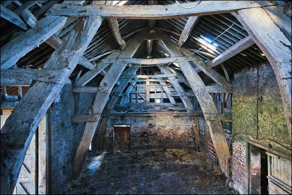
Barn. Perhaps C16, altered. Cruck-framed. Present cladding of coursed sandstone rubble (probably replacing timber-framing), slate roof. Four bays on north-south axis; shippon added at south end of less interest; west side has wagon entrance to 3rd bay protected by porch with short cheeks and carried-down roof; various large attached outbuildings not included in the item. North gable weather-boarded, and below this an attached lean-to garage or cart shed of snecked sandstone, to the north of which is a long low range of 4 pigsties with monopitched roof of stone slates, random rubble walls with 4 doorways. The principal feature of interest is the interior cruck frame of the barn, composed of 4 full cruck trusses including one at the north gable: these have blades of large scantling, collars, yokes, 2 pairs of spurs, and dorsals carrying 2 pairs of trenched purlins with curved windbraces above and below; the gable end truss has in addition a kingpost (tie-beam not visible) and 2 angle struts near the apex. The ridge lies diagonally between the tops of the blades which touch but are joined only by the yokes. In the 2nd bay on the east side are remains of timber-framed walling, including wall posts, high rails (below which the wall is now stone) and straight arch-bracing.
Listing NGR: SD6289125465
External links are from the relevant listing authority and, where applicable, Wikidata. Wikidata IDs may be related buildings as well as this specific building. If you want to add or update a link, you will need to do so by editing the Wikidata entry.


Other nearby listed buildings