Approximate Location Map
Large Map »
Latitude: 53.781 / 53°46'51"N
Longitude: -2.8855 / 2°53'7"W
OS Eastings: 341745
OS Northings: 431999
OS Grid: SD417319
Mapcode National: GBR 8S9Q.2B
Mapcode Global: WH85J.N746
Plus Code: 9C5VQ4J7+CQ
Entry Name: Churchyard Wall and Gateway South of the Church of St John the Evangelist
Listing Date: 11 June 1986
Grade: II
Source: Historic England
Source ID: 1362360
English Heritage Legacy ID: 183603
ID on this website: 101362360
Location: St John's Roman Catholic Church, Ribby, Fylde, Lancashire, PR4
County: Lancashire
District: Fylde
Civil Parish: Kirkham
Built-Up Area: Kirkham
Traditional County: Lancashire
Lieutenancy Area (Ceremonial County): Lancashire
Church of England Parish: Kirkham St Michael
Church of England Diocese: Blackburn
Tagged with: Churchyard wall
KIRKHAM RIBBY ROAD
SD 43 SW
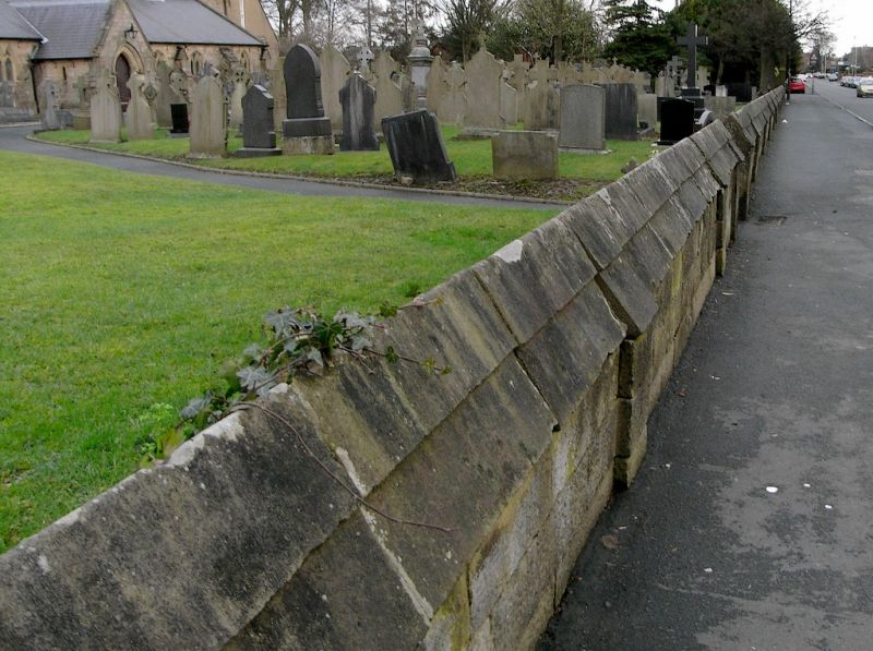
9/33 Churchyard wall and gateway
south of the Church of St.
John the Evangelist
-
- II
Churchyard wall and entrance gateway, 1845 by Augustus Welby Northmore Pugin. Dressed sandstone. Wall runs along Ribby Road and has copings with a profile like that of a mansard roof. Gateway is surmounted by a stepped coping with a
similar profile and has a segmental pointed chamfered arch carried on
chamfered jambs which are buttressed behind.
Listing NGR: SD4174531999
External links are from the relevant listing authority and, where applicable, Wikidata. Wikidata IDs may be related buildings as well as this specific building. If you want to add or update a link, you will need to do so by editing the Wikidata entry.


Other nearby listed buildings
