Approximate Location Map
Large Map »
Latitude: 51.3304 / 51°19'49"N
Longitude: 0.1335 / 0°8'0"E
OS Eastings: 548734
OS Northings: 161191
OS Grid: TQ487611
Mapcode National: GBR RC.VR4
Mapcode Global: VHHPC.8TFJ
Plus Code: 9F3284JM+4C
Entry Name: Front Garden Wall to North and North West of Village House
Listing Date: 16 January 1975
Grade: II
Source: Historic England
Source ID: 1362405
English Heritage Legacy ID: 357232
ID on this website: 101362405
Location: Halstead, Sevenoaks, Kent, TN14
County: Kent
District: Sevenoaks
Civil Parish: Halstead
Built-Up Area: Halstead
Traditional County: Kent
Lieutenancy Area (Ceremonial County): Kent
Church of England Parish: Halstead St Margaret
Church of England Diocese: Rochester
Tagged with: Wall
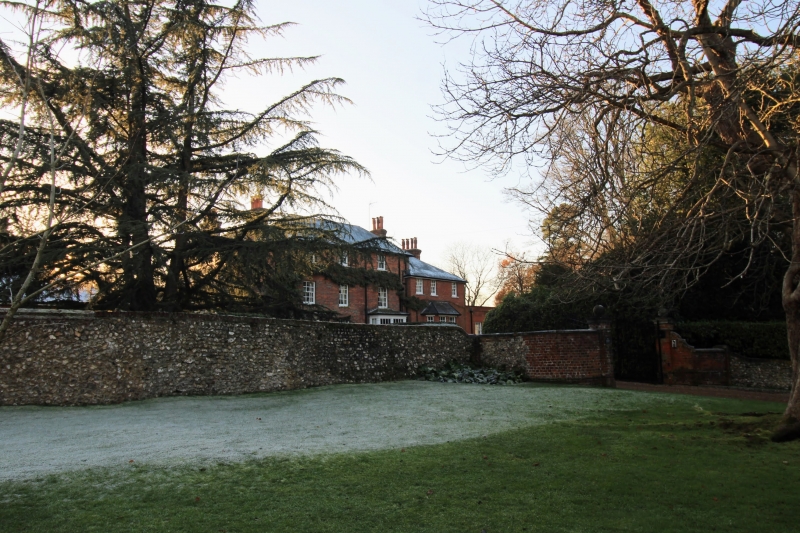
HALSTEAD HALSTEAD
1.
5280
Church Road
(south-West Side)
Front garden wall to
North and North-West of
Village House
TQ 4861 14/496
II
2.
Curved boundary wall of flint rubble with brick coping. 2 square brick gate
piers with stone cornices and ball finials.
Listing NGR: TQ4873461191
External links are from the relevant listing authority and, where applicable, Wikidata. Wikidata IDs may be related buildings as well as this specific building. If you want to add or update a link, you will need to do so by editing the Wikidata entry.


Other nearby listed buildings
