Latitude: 54.0649 / 54°3'53"N
Longitude: -2.5489 / 2°32'55"W
OS Eastings: 364174
OS Northings: 463351
OS Grid: SD641633
Mapcode National: GBR BPMF.ZM
Mapcode Global: WH95G.T3F4
Plus Code: 9C6V3F72+WF
Entry Name: Summersgill Farmhouse
Listing Date: 4 October 1967
Grade: II
Source: Historic England
Source ID: 1362578
English Heritage Legacy ID: 182666
ID on this website: 101362578
Location: Lancaster, Lancashire, LA2
County: Lancashire
District: Lancaster
Civil Parish: Wray-with-Botton
Traditional County: Lancashire
Lieutenancy Area (Ceremonial County): Lancashire
Church of England Parish: Wray Holy Trinity
Church of England Diocese: Blackburn
Tagged with: Farmhouse
SD 66 SW WRAY-WITH-BOTTON
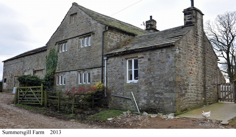
5/130 Summersgill Farmhouse 4-10-1967 - II
House, late C17th. Sandstone rubble with stone slate roof. 2 storeys. North wall has single-storey extension, probably C19th, extending forwards at left. To its right is a 3-light window with flat-faced mullions. At the left on the 1st floor is a 3-Light rebated and chamfered mullioned window. To its right is a window with rebated and chamfered surround. The present entrance is into the extension, in the angle with the main house and covered by a modern timber porch. It has a re-set moulded surround with segmental head inscribed: 'RA 1672 IR'. The right-hand gable wall has a projecting stack with offsets. The left-hand gable has a drip course over the 2 3-light ground-floor windows which have rebated surrounds and channelled flat-faced mullions. On the 1st floor are 2 3-light rebated and chamfered mullioned windows under a hood. Above is a similar 2-light blocked attic window. Inside, above the door from the extension into the main house, is a a plaque shaped like an inverted heart. It is inscribed: 'RRE 1725'. At the rear of the original house is a spiral stone stair, the treads now covered with timber. The right-hand room has an exposed chamfered main ceiling joist.
Listing NGR: SD6417463351
External links are from the relevant listing authority and, where applicable, Wikidata. Wikidata IDs may be related buildings as well as this specific building. If you want to add or update a link, you will need to do so by editing the Wikidata entry.


Other nearby listed buildings