Latitude: 51.1489 / 51°8'55"N
Longitude: 0.8741 / 0°52'26"E
OS Eastings: 601113
OS Northings: 142772
OS Grid: TR011427
Mapcode National: GBR RWP.ZRY
Mapcode Global: VHKKN.3DG4
Plus Code: 9F324VXF+GJ
Entry Name: 25, HIGH STREET (See details for further address information)
Listing Date: 24 September 1951
Grade: II
Source: Historic England
Source ID: 1362830
English Heritage Legacy ID: 179932
ID on this website: 101362830
Location: Ashford, Kent, TN24
County: Kent
District: Ashford
Electoral Ward/Division: Victoria
Parish: Non Civil Parish
Built-Up Area: Ashford (Ashford)
Traditional County: Kent
Lieutenancy Area (Ceremonial County): Kent
Tagged with: Building
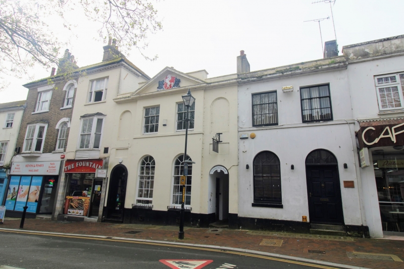
1. 5344 HIGH STREET (South Side) No 25 No 27 TR 0142 NW 1/4 24.9.51. II GV 2. Dated 1835. Originally a Savings Bank. 2 storeys and basement stuccoed. Cornice and parapet with pediment above the 2 window bays of No 25 containing a cartouche in the tympanum, and a panel above the centre of No 27. The cartouche has "Invicta 1835" and a white horse rampant, the Kent County symbol. Slate roof. 4 window bays. The 2 window bays of No 25 project slightly. The recessed sections on each side of this projection have a round-headed recess on each floor flanking it, which are all blind except that on the ground floor of the west wing which gives entrance to a passage between Nos 25 and 27. Round-headed windows on the ground floor with glazing bars intact. Stone flags to passageway.
Nos 19, 19A, 21 to 25 (odd), 25A, 27, 31 and 31A form a group.
Listing NGR: TR0111342772
External links are from the relevant listing authority and, where applicable, Wikidata. Wikidata IDs may be related buildings as well as this specific building. If you want to add or update a link, you will need to do so by editing the Wikidata entry.


Other nearby listed buildings