Latitude: 51.314 / 51°18'50"N
Longitude: -1.9444 / 1°56'39"W
OS Eastings: 403968
OS Northings: 157214
OS Grid: SU039572
Mapcode National: GBR 3WT.F7J
Mapcode Global: VHB4P.77XH
Plus Code: 9C3W8374+J6
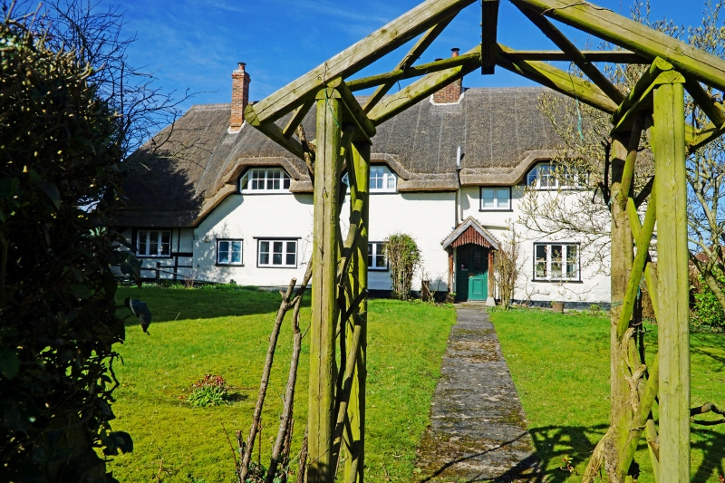
Entry Name: Church Farmhouse
Listing Date: 25 March 1988
Grade: II
Source: Historic England
Source ID: 1364617
English Heritage Legacy ID: 312126
ID on this website: 101364617
Location: Urchfont, Wiltshire, SN10
County: Wiltshire
Civil Parish: Urchfont
Built-Up Area: Urchfont
Traditional County: Wiltshire
Lieutenancy Area (Ceremonial County): Wiltshire
Tagged with: Farmhouse Thatched farmhouse
URCHFONT HIGH STREET
SU 0357
(north side)
10/220 Church Farmhouse
II
Farmhouse, now house. C15, and early C18, and C19. Colourwashed
English bond brick with left bay timber framed. Thatched roof.
Single storey and upper floor, four bays. Originally a 3-bay
minimum open hall house, of which only the left bay survives
extensive rebuilding and heightening in C18, and right extension in
C19. Central living room in former hall incorporates second bay.
Early C19 stone bay with brick quoins added to right, incorporating
passage with entrance, a 4-panelled door, half glazed, with rustic
porch. Two and 3-light late C19-early C20 windows and 3 paned
flush dormers. Three flush dormers to rear. Three brick stacks.
Single storey C20 flat roofed addition along whole of rear.
Interior: Three cruck framed trusses of original structure survive,
only the left surviving to apex, variant of type C with yoke
trenched in and twice pegged carrying diagonal ridge clasped
between unconnected tops of crucks. Wattle and daub infilling,
smoke blackened to hall side. Living room has bar chamfer stops to
crossed beams, and bressumer in front of inserted brick stack,
perhaps part of timber framed predecessor.
Listing NGR: SU0396857214
External links are from the relevant listing authority and, where applicable, Wikidata. Wikidata IDs may be related buildings as well as this specific building. If you want to add or update a link, you will need to do so by editing the Wikidata entry.


Other nearby listed buildings