Approximate Location Map
Large Map »
Latitude: 51.3732 / 51°22'23"N
Longitude: -1.606 / 1°36'21"W
OS Eastings: 427522
OS Northings: 163863
OS Grid: SU275638
Mapcode National: GBR 5Z4.W85
Mapcode Global: VHC1Y.3RV6
Plus Code: 9C3W99FV+7J
Entry Name: Moonrakers
Listing Date: 30 July 1986
Grade: II
Source: Historic England
Source ID: 1365494
English Heritage Legacy ID: 310811
ID on this website: 101365494
Location: Great Bedwyn, Wiltshire, SN8
County: Wiltshire
Civil Parish: Great Bedwyn
Built-Up Area: Great Bedwyn
Traditional County: Wiltshire
Lieutenancy Area (Ceremonial County): Wiltshire
Tagged with: Building
GREAT BEDWYN CHURCH STREET
(north-west side)
SU 25 SE
5/87
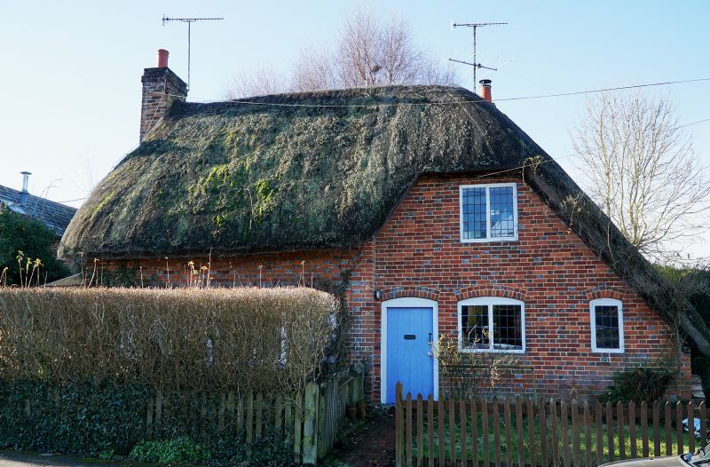
No 53 Moonrakers
II
Cottage. C17 - early C18. Timber framed with brick noggings.
Single-storey and attic, 2 bays, originally kitchen left, parlour
right. Door to kitchen now replaced with gable door in C20 wood
porch. Leaded casement windows. External stacks to both gables.
Queen strut clasped purlin roof. Thatch swept over 1 dormer and
half-hipped. Rear extension, tiled roof and clad in waney
boarding.
Listing NGR: SU2752263863
External links are from the relevant listing authority and, where applicable, Wikidata. Wikidata IDs may be related buildings as well as this specific building. If you want to add or update a link, you will need to do so by editing the Wikidata entry.


Other nearby listed buildings
