Approximate Location Map
Large Map »
Latitude: 51.7436 / 51°44'36"N
Longitude: -2.2131 / 2°12'47"W
OS Eastings: 385385
OS Northings: 205010
OS Grid: SO853050
Mapcode National: GBR 1MK.R93
Mapcode Global: VH94Y.LFDQ
Plus Code: 9C3VPQVP+CQ
Entry Name: Stroud Methodist Church
Listing Date: 25 June 1974
Grade: II
Source: Historic England
Source ID: 1366140
English Heritage Legacy ID: 131373
ID on this website: 101366140
Location: Stroud, Gloucestershire, GL5
County: Gloucestershire
District: Stroud
Civil Parish: Stroud
Built-Up Area: Stroud
Traditional County: Gloucestershire
Lieutenancy Area (Ceremonial County): Gloucestershire
Church of England Parish: Stroud St Laurence
Church of England Diocese: Gloucester
Tagged with: Protestant church building
This list entry was subject to a Minor Amendment on 28 October 2021 to add sources and update and reformat text to current standards
SO 8505
5/206
SO 8504
6/206
CASTLE STREET (South Side)
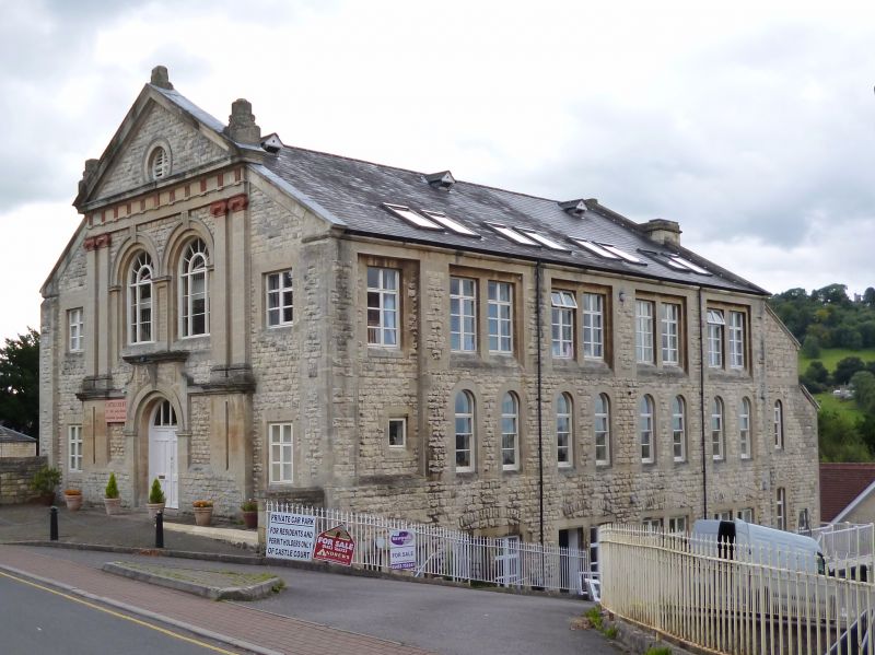
Stroud Methodist Church
II
1876 (dated) by J. Tait of Leicester. Rock-faced rustication with ashlar quoins. Pitched slate roof. Two storeys, Palladian temple front: coupled Ionic pilasters taking entablature with pediment. Acroteria, Oculus in tympanum. Two arcuated windows with glazing bars, keystones, moulded surrounds and imposts on first floor. Round arched doorway in Baroque surround. Two storey flanking bay with l range of casements each, and ramped coping to roof.
Listing NGR: SO8538505010
External links are from the relevant listing authority and, where applicable, Wikidata. Wikidata IDs may be related buildings as well as this specific building. If you want to add or update a link, you will need to do so by editing the Wikidata entry.


Other nearby listed buildings
