Latitude: 51.1494 / 51°8'57"N
Longitude: 0.6855 / 0°41'7"E
OS Eastings: 587923
OS Northings: 142335
OS Grid: TQ879423
Mapcode National: GBR QV4.S5P
Mapcode Global: VHJN2.TCSP
Plus Code: 9F324MXP+Q6
Entry Name: Hartnup House
Listing Date: 17 September 1952
Grade: II*
Source: Historic England
Source ID: 1366291
English Heritage Legacy ID: 181281
ID on this website: 101366291
Location: Smarden, Ashford, Kent, TN27
County: Kent
District: Ashford
Civil Parish: Smarden
Built-Up Area: Smarden
Traditional County: Kent
Lieutenancy Area (Ceremonial County): Kent
Tagged with: House
1. 5272 SMARDEN WATER LANE Hartnup House TQ 8742 23/16 17.9.52.
II*
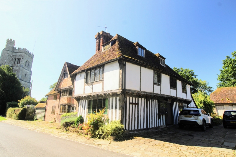
2. L-shaped timber-framed building. The north-west wing is probably C15. It has plaster infilling colour-washed. The ground floor is close-studded. The first floor oversails on both fronts on the protruding ends of the floor joists and brackets. Dragon beam with moulded post. Hipped tiled roof. Casement windows with small square leaded panes. Two storeys and attics. Three windows and 2 hipped dormers facing north-west, one window and one hipped dormer facing north-east. The south-east wing was added by Matthew Hartnup in 1671. This has red brick infilling and one bay window of 5 lights on the ground and first floors, with a gable oversailing on a bessummer, carved with the figures of 2 hippototami and between these the words, "Matthew Hartnup" and containing an attic window with the date 1671 over it. The south-east window bay of this wing has been refaced in red brick and grey headers. Two windows. Doorcase with single petalled roses of York and Lancaster. The courtyard to Hartnup House is paved with Bethersden marble.
Listing NGR: TQ8792342335
External links are from the relevant listing authority and, where applicable, Wikidata. Wikidata IDs may be related buildings as well as this specific building. If you want to add or update a link, you will need to do so by editing the Wikidata entry.


Other nearby listed buildings