Approximate Location Map
Large Map »
Latitude: 52.6785 / 52°40'42"N
Longitude: -2.6805 / 2°40'49"W
OS Eastings: 354085
OS Northings: 309195
OS Grid: SJ540091
Mapcode National: GBR BM.48RS
Mapcode Global: WH8BV.SXRZ
Plus Code: 9C4VM8H9+CQ
Entry Name: Group of 5 Coffin Slabs Approximately One Metre to South of Nave of Church of St Eata
Listing Date: 17 February 1985
Grade: II
Source: Historic England
Source ID: 1366967
English Heritage Legacy ID: 259247
ID on this website: 101366967
Location: The Parish Church of St Eata, Atcham, Shropshire, SY5
County: Shropshire
Civil Parish: Atcham
Traditional County: Shropshire
Lieutenancy Area (Ceremonial County): Shropshire
Church of England Parish: Atcham St Eata
Church of England Diocese: Lichfield
Tagged with: Coffin slab
SJ 50 NW ATCHAM C.P. ATCHAM
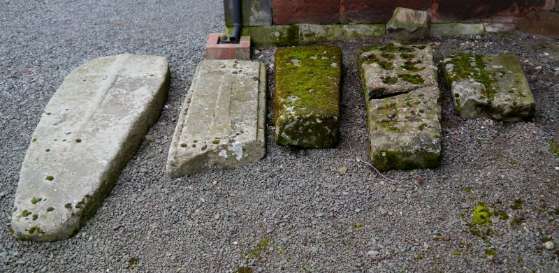
5/22 Group of 5 coffin slabs
- approximately one metre
to south of nave of
Church of St Eata
GV II
Group of 5 coffin slabs. Probably C14. Grey sandstone. Second from
north has incised Celtic cross and reeded edge, fourth from north has
raised cross and rebated edge, and southerly one has raised cross and
rounded corners.
Listing NGR: SJ5408509195
External links are from the relevant listing authority and, where applicable, Wikidata. Wikidata IDs may be related buildings as well as this specific building. If you want to add or update a link, you will need to do so by editing the Wikidata entry.


Other nearby listed buildings
