Latitude: 51.781 / 51°46'51"N
Longitude: -1.4854 / 1°29'7"W
OS Eastings: 435599
OS Northings: 209273
OS Grid: SP355092
Mapcode National: GBR 6VS.99C
Mapcode Global: VHC02.6HLJ
Plus Code: 9C3WQGJ7+9V
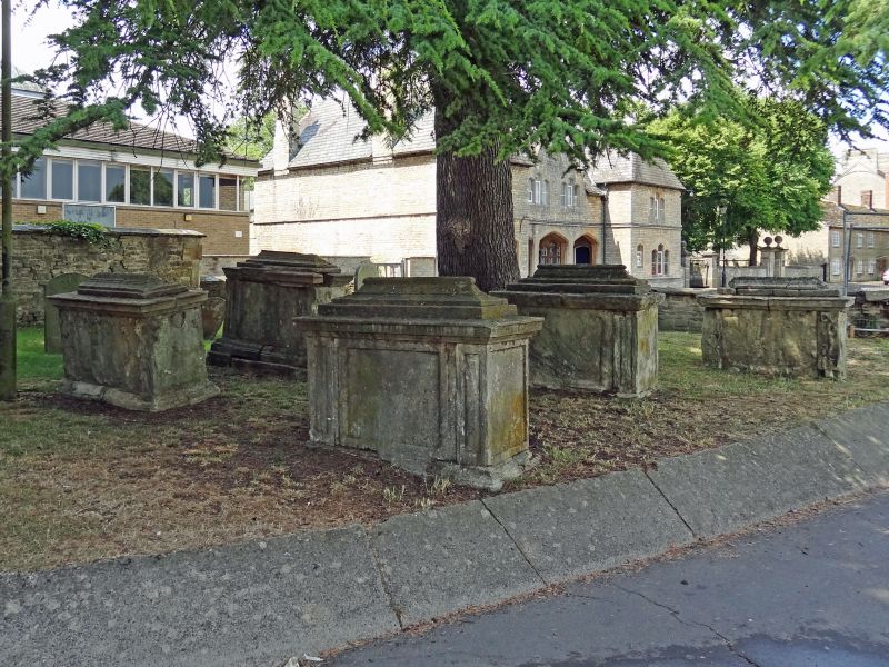
Entry Name: Group of 8 Chest Tombs Approximately 14 Metres and 22 Metres North North West and 25 Metres North of Nave of Church of St Mary
Listing Date: 3 March 1988
Grade: II
Source: Historic England
Source ID: 1367915
English Heritage Legacy ID: 252601
ID on this website: 101367915
Location: St Mary's Church, Witney, West Oxfordshire, OX28
County: Oxfordshire
District: West Oxfordshire
Civil Parish: Witney
Built-Up Area: Witney
Traditional County: Oxfordshire
Lieutenancy Area (Ceremonial County): Oxfordshire
Church of England Parish: Witney
Church of England Diocese: Oxford
Tagged with: Chest tomb
WITNEY CHURCH GREEN
SP3509S (South side)
11/41 Group of 8 chest tombs approx.
14m. and 22m. NNW and 25m. N
of nave of Church of St. Mary
GV II
8 chest tombs. Two chest tombs approximately 14 metres north-north-west. Early
C18. Limestone. Tomb to south has cyma-moulded plinth, splayed cornice to top
and 2 inscription panels with raised surrounds. Tomb to north has raised
surround to narrow panels and central inscription panel, with skulls flanking
winged cherub's head over worn inscription. Chest tomb approximately 22 metres
north-north-west. Early/mid C18. Limestone. Cyma-moulded plinth and cornice:
carved scrolls flank inscription panel. Group of 5 chest tombs approximately 25
metres north. C18. Limestone. All have moulded tops. Leake tomb to south-west,
dated 1767 and 1750s, has rococo cartouche. Similar mid C18 tomb to north. Tombs
to east are dated 1786, and another commemorates Anne Fisher, died early C19.
Listing NGR: SP3559609263
External links are from the relevant listing authority and, where applicable, Wikidata. Wikidata IDs may be related buildings as well as this specific building. If you want to add or update a link, you will need to do so by editing the Wikidata entry.


Other nearby listed buildings