Approximate Location Map
Large Map »
Latitude: 51.6702 / 51°40'12"N
Longitude: -1.0885 / 1°5'18"W
OS Eastings: 463133
OS Northings: 197218
OS Grid: SU631972
Mapcode National: GBR B1N.7MZ
Mapcode Global: VHCYB.28XZ
Plus Code: 9C3WMWC6+3J
Entry Name: The Lamb Public House
Listing Date: 18 July 1963
Last Amended: 3 April 1987
Grade: II
Source: Historic England
Source ID: 1368855
English Heritage Legacy ID: 248906
Also known as: Lamb
The Lamb, Oxford
ID on this website: 101368855
Location: Chalgrove, South Oxfordshire, OX44
County: Oxfordshire
District: South Oxfordshire
Civil Parish: Chalgrove
Built-Up Area: Chalgrove
Traditional County: Oxfordshire
Lieutenancy Area (Ceremonial County): Oxfordshire
Church of England Parish: Chalgrove
Church of England Diocese: Oxford
Tagged with: Pub Thatched pub
CHALGROVE MILL LANE
SU6397 (West side)
9/60 The Lamb Public House
18/07/63 (Formerly listed as The Lamb
Inn)
- II
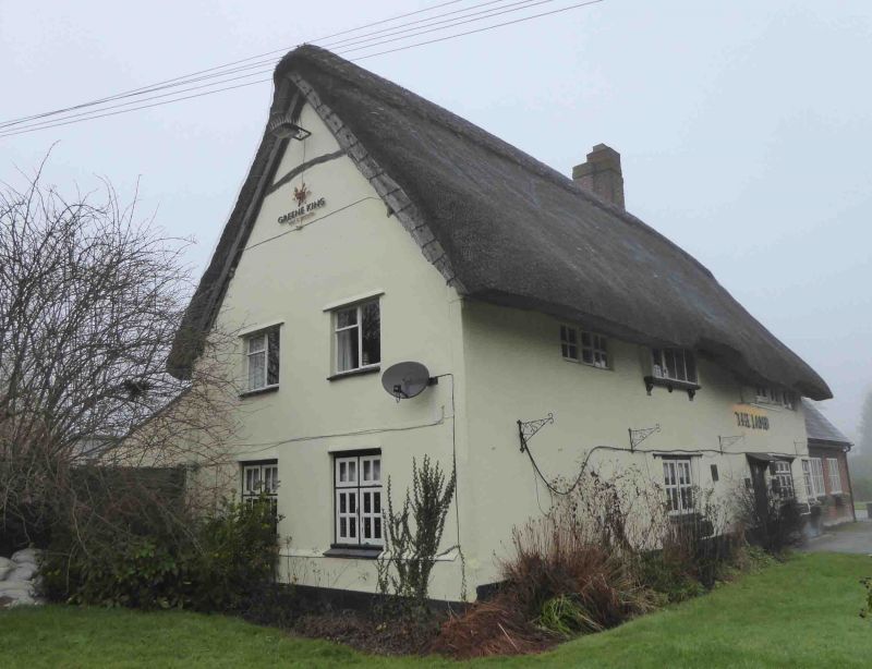
House, now public house. Mid/late C17. Rendered; gabled thatch roof; brick ridge
stacks. L-plan with rear right wing. 2 storeys; 4-window range of scattered
fenestration. C20 door and casements, except first-floor 3-light leaded casement
to right and 4-light leaded casement on carved brackets to left. Rear wing of 2
storeys and attic and similar materials. C20 outshut to right. Interior: bar to
right has chamfered beams and segmental-arched chamfered fireplace.
Listing NGR: SU6313397218
External links are from the relevant listing authority and, where applicable, Wikidata. Wikidata IDs may be related buildings as well as this specific building. If you want to add or update a link, you will need to do so by editing the Wikidata entry.


Other nearby listed buildings
