Latitude: 51.6011 / 51°36'4"N
Longitude: -1.1241 / 1°7'26"W
OS Eastings: 460763
OS Northings: 189506
OS Grid: SU607895
Mapcode National: GBR 911.JMN
Mapcode Global: VHCYP.G0LX
Plus Code: 9C3WJV2G+F9
Entry Name: National Westminster Bank
Listing Date: 9 December 1949
Last Amended: 9 February 1988
Grade: II
Source: Historic England
Source ID: 1368919
English Heritage Legacy ID: 249252
ID on this website: 101368919
Location: Wallingford, South Oxfordshire, OX10
County: Oxfordshire
District: South Oxfordshire
Civil Parish: Wallingford
Built-Up Area: Wallingford
Traditional County: Berkshire
Lieutenancy Area (Ceremonial County): Oxfordshire
Tagged with: Bank building
WALLINGFORD HIGH STREET
SU6089NE, SU6089SE (North side)
Wallingford
10/84, 11/84 No.82 (National Westminster
09/12/49 Bank)
(Formerly listed as No.64
(Westminster Bank))
GV II
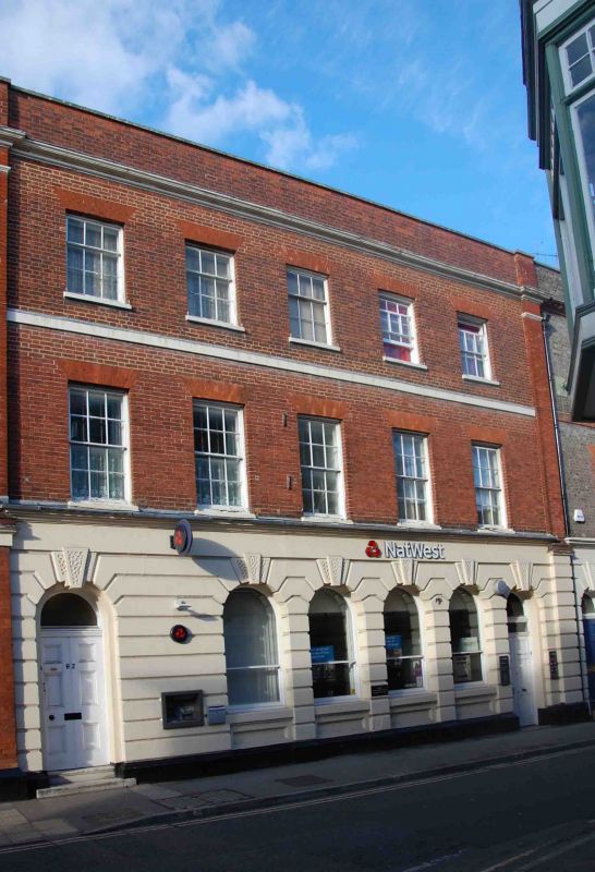
House, now bank. Late C18, with mid C19 rustication to ground floor, and C20
alterations to interior. Rendered brick plinth; rendered chamfered rustication
on brick to ground floor; red brick; roof not visible. 3-storey, 5-window
range. 6-panel doors with fanlights to left and right. Four C20 windows to
original arcaded openings to centre. All ground floor openings have keystones.
Cornice between ground and first floors. 12-pane unhorned sashes with cambered
brick heads to first floor. 9-pane unhorned sashes with cambered brick heads to
second floor. Painted moulded cornice and plain brick parapet to eaves.
Interior: C20 banking hall to ground floor. Early C19 addition to right with mid
C19 rustication to ground floor. Rendered brick plinth; rendered chamfered
rustication on brick to ground floor; grey brick with red brick dressings; roof
not visible. 3-storey, single-window range. 6-panel door with fanlight to left.
Two C20 windows to original arcaded openings to centre and right. Tripartite
sashes with cambered brick heads to first and second floors. Flat brick band
between first and second floors. Brick cornice and parapet to roof.
WALLINGFORD HIGH STREET
(North side)
Wallingford
The Lamb Arcade
See under Castle Street (east side).
Listing NGR: SU6076389506
External links are from the relevant listing authority and, where applicable, Wikidata. Wikidata IDs may be related buildings as well as this specific building. If you want to add or update a link, you will need to do so by editing the Wikidata entry.


Other nearby listed buildings