Approximate Location Map
Large Map »
Latitude: 51.645 / 51°38'41"N
Longitude: -1.0046 / 1°0'16"W
OS Eastings: 468972
OS Northings: 194491
OS Grid: SU689944
Mapcode National: GBR B1Y.YML
Mapcode Global: VHDVT.JXSB
Plus Code: 9C3WJXVW+X5
Entry Name: Town Hall
Listing Date: 18 July 1963
Grade: II*
Source: Historic England
Source ID: 1369012
English Heritage Legacy ID: 247656
ID on this website: 101369012
Location: Watlington, South Oxfordshire, OX49
County: Oxfordshire
District: South Oxfordshire
Civil Parish: Watlington
Built-Up Area: Watlington
Traditional County: Oxfordshire
Lieutenancy Area (Ceremonial County): Oxfordshire
Church of England Parish: Watlington
Church of England Diocese: Oxford
Tagged with: City hall Seat of local government
SU6894
6/185
18/07/63
WATLINGTON
HIGH STREET
(South side)
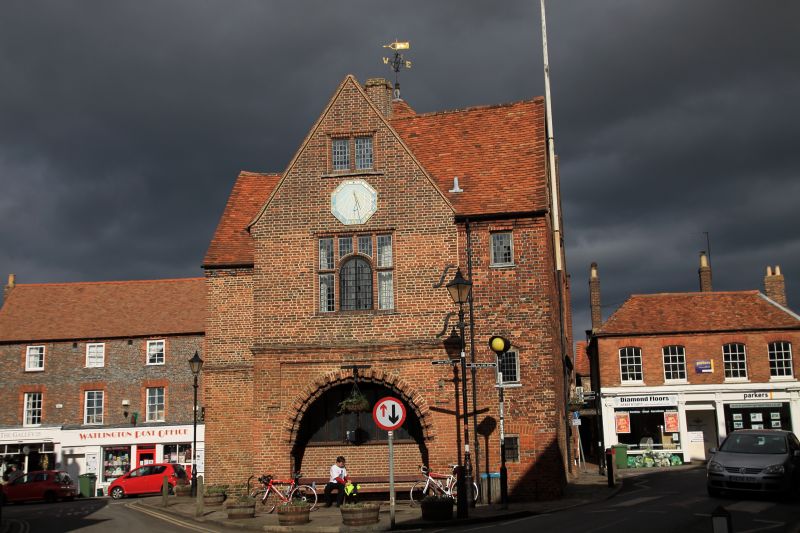
Town Hall
GV
II*
Town hall. Built 1665 for Thomas Stonor. Later C17/early C18 one-bay extension
to rear right. Random bond brick; old tile roof; brick stack. Original T-plan
now L-plan with short rear wing to right of front. Two storeys and attic. Left
gable wall has hood-mould over toothed round-arch on moulded imposts.
First-floor 3-light brick-mullioned ovolo-moulded window with round-arched
central light; second floor has 2-light brick-mullioned ovolo-moulded window.
Similar right gable wall, rear left gable wall with clock on blocked window and
2-storey left side wall. All ground-floor entrances have C20 iron gates; moulded
string course and stepped eaves course to original 1665 building. Gabled roof;
ridge stack; bell cupola with weathercock on hipped roof. Interior not
inspected: the first floor was used by the Watlington Free Grammar School, and
the partly-open ground floor as a market.
(Buildings of England: Oxfordshire, p.830; V.C.H.: Oxfordshire, Vol.IIIII,
p.212).
Listing NGR: SU6897294491
External links are from the relevant listing authority and, where applicable, Wikidata. Wikidata IDs may be related buildings as well as this specific building. If you want to add or update a link, you will need to do so by editing the Wikidata entry.


Other nearby listed buildings
