Approximate Location Map
Large Map »
Latitude: 51.6452 / 51°38'42"N
Longitude: -1.0046 / 1°0'16"W
OS Eastings: 468971
OS Northings: 194508
OS Grid: SU689945
Mapcode National: GBR B1Y.YMJ
Mapcode Global: VHDVT.JXR6
Plus Code: 9C3WJXWW+35
Entry Name: Artsake
Listing Date: 11 December 1985
Grade: II
Source: Historic England
Source ID: 1181155
English Heritage Legacy ID: 247646
ID on this website: 101181155
Location: Watlington, South Oxfordshire, OX49
County: Oxfordshire
District: South Oxfordshire
Civil Parish: Watlington
Built-Up Area: Watlington
Traditional County: Oxfordshire
Lieutenancy Area (Ceremonial County): Oxfordshire
Church of England Parish: Watlington
Church of England Diocese: Oxford
Tagged with: Building
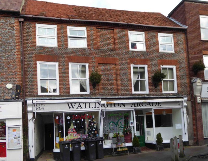
WATLINGTON HIGH STREET
SU6894 (North side)
6/175 No.6 (Artsake)
GV II
Town house, now shop and flat. Late C16, refronted and remodelled in mid C17:
C17 rear wing. Originally timber framed. Header bond grey brick with red brick
dressings; gabled old tile roof; brick rear lateral stack. L-plan with rear
right wing. 3 storeys. 5-window range. C20 door and shop windows set in late C19
shop front with C20 door to left. Gauged brick flat arches over mid C19
two-light horned sashes; flat brick arches over similar second-floor sashes;
blind windows in central bay; dentilled eaves. C17 two-storey rear wing of
rectangular timber framing with gabled old tile roof and C19 brick ridge stack;
2-light wood-mullioned ovolo-moulded window to right, C17 moulded architraves
survive of rear gable first-floor window, and C18 five-light wood-mullioned
window to left. Interior: chamfered bressumer over open fireplace to rear right;
square timber framing to rear first-floor wall; C18 two-panelled doors; 3
queen-post trusses with butt purlins. Rear wing has chamfered beams including
roll-stopped ground-floor beam; 3 roof trusses have principals morticed into
collar and trenched through purlins.
Listing NGR: SU6897694511
External links are from the relevant listing authority and, where applicable, Wikidata. Wikidata IDs may be related buildings as well as this specific building. If you want to add or update a link, you will need to do so by editing the Wikidata entry.


Other nearby listed buildings
