Approximate Location Map
Large Map »
Latitude: 51.5718 / 51°34'18"N
Longitude: -1.2026 / 1°12'9"W
OS Eastings: 455359
OS Northings: 186187
OS Grid: SU553861
Mapcode National: GBR 91B.GR3
Mapcode Global: VHCYN.3RLD
Plus Code: 9C3WHQCW+PX
Entry Name: The Smithy
Listing Date: 9 April 1952
Grade: II
Source: Historic England
Source ID: 1369064
English Heritage Legacy ID: 247932
ID on this website: 101369064
Location: Aston Upthorpe, South Oxfordshire, OX11
County: Oxfordshire
District: South Oxfordshire
Civil Parish: Aston Upthorpe
Built-Up Area: Aston Tirrold
Traditional County: Berkshire
Lieutenancy Area (Ceremonial County): Oxfordshire
Church of England Parish: Aston Tirrold
Church of England Diocese: Oxford
Tagged with: Smithy
SU5586
7/48
09/04/52
ASTON UPTHORPE
THORPE STREET
(East side)
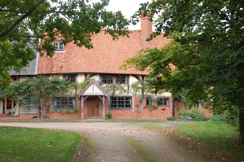
The Smithy
GV
II
House, now 2 houses. C17 with C20 alterations. Large timber framing with arch
braces; rendered infill; old plain-tile roof; brick ridge stack to right of
centre with diagonally set tapering flues. 2 storeys and attic; 4-window range.
Part-glazed plank door to porch to left of centre with gabled plain-tile roof.
Glazed plank door to porch to right with gabled plain-tile roof. Angled bay with
hipped plain-tile roof to left, and centre. Single-light casement to right of
centre. 3-light wood casements to first floor, except 4-light casement to right.
Raking dormer to left. Extensive beaming to interior, rebuilt open fireplace to
ground floor centre. Queen-post roof. 2-storey, single-window extension to
right. Timber framing with rendered infill; plain-tile, half-hipped roof. Square
bay window with lean-to roof to ground floor. 2-light wood casement to first
floor.
Listing NGR: SU5535986187
External links are from the relevant listing authority and, where applicable, Wikidata. Wikidata IDs may be related buildings as well as this specific building. If you want to add or update a link, you will need to do so by editing the Wikidata entry.


Other nearby listed buildings
