Latitude: 51.5375 / 51°32'14"N
Longitude: -0.9019 / 0°54'7"W
OS Eastings: 476253
OS Northings: 182637
OS Grid: SU762826
Mapcode National: GBR C4S.DT2
Mapcode Global: VHDWG.BM16
Plus Code: 9C3XG3PX+X6
Entry Name: 48 and 50, Hart Street
Listing Date: 25 January 1951
Last Amended: 22 October 1974
Grade: II
Source: Historic England
Source ID: 1369130
English Heritage Legacy ID: 246176
ID on this website: 101369130
Location: Henley-on-Thames, South Oxfordshire, RG9
County: Oxfordshire
District: South Oxfordshire
Civil Parish: Henley-on-Thames
Built-Up Area: Henley-on-Thames
Traditional County: Oxfordshire
Lieutenancy Area (Ceremonial County): Oxfordshire
Church of England Parish: Henley-on-Thames
Church of England Diocese: Oxford
Tagged with: Building
1. HART STREET 5355 (South Side)
Nos 48 & 50 [Formerly listed as part of No 48 and No 50 (Speakers' House)
SU 7582 1/35 25.1.51.
II GV
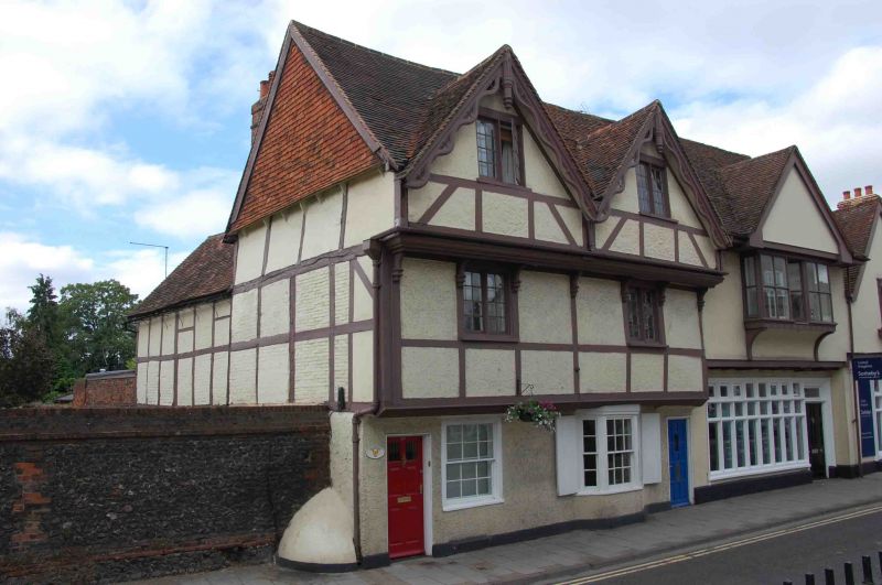
2. C15/C16. Timber framed with roughcast plaster infill and old tiled roof. 3 storeys, 2 windows under gables with pierced and scalloped barge boards and finials. Each floor is jettied out with moulded bressumer, that of 2nd floor supported in wooden brackets. Top floors have early C19 casement windows with glazing bars. Ground floor has 1 unbarred sash and 1 late C18/early C19 canted bay with sashes and glazing bars. 2 doors. Eastern facade has tile hung gable end.
Nos 2 to 8 (even) Nos 14 to 36 (even) including Adam House, and Nos 40 44, and gates and piers 48, 50, The Old School House and the Rectory Garden Wall form a group with Nos 5 to 39 (odd), the Drinking Fountain, the Parish Church of St Mary and the raised pavement at the east end of Hart Street.
Listing NGR: SU7625382637
External links are from the relevant listing authority and, where applicable, Wikidata. Wikidata IDs may be related buildings as well as this specific building. If you want to add or update a link, you will need to do so by editing the Wikidata entry.


Other nearby listed buildings