Approximate Location Map
Large Map »
Latitude: 51.5541 / 51°33'14"N
Longitude: -0.9497 / 0°56'58"W
OS Eastings: 472914
OS Northings: 184432
OS Grid: SU729844
Mapcode National: GBR C4J.DQN
Mapcode Global: VHDWF.H68H
Plus Code: 9C3XH332+J4
Entry Name: Lawrences Farmhouse
Listing Date: 13 February 1985
Grade: II
Source: Historic England
Source ID: 1369313
English Heritage Legacy ID: 247027
ID on this website: 101369313
Location: Bix, South Oxfordshire, RG9
County: Oxfordshire
District: South Oxfordshire
Civil Parish: Bix and Assendon
Traditional County: Oxfordshire
Lieutenancy Area (Ceremonial County): Oxfordshire
Church of England Parish: Bix
Church of England Diocese: Oxford
Tagged with: Farmhouse
BIX
SU78SW
6/9 Lawrences Farmhouse
- II
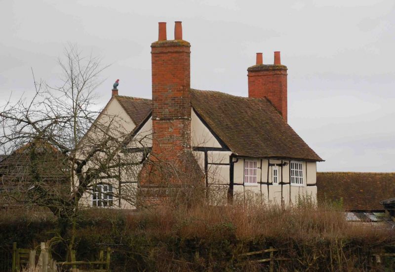
Farmhouse. Early C17. Irregular timber-frame, rendered infill, tile roof,
brick stacks to gable ends. 2-unit plan. 2-storey, 2-window range. Casement
windows. 4 panel part-glazed door to centre. Interior not inspected.
Listing NGR: SU7291484432
External links are from the relevant listing authority and, where applicable, Wikidata. Wikidata IDs may be related buildings as well as this specific building. If you want to add or update a link, you will need to do so by editing the Wikidata entry.


Other nearby listed buildings
