Latitude: 51.5396 / 51°32'22"N
Longitude: -0.9046 / 0°54'16"W
OS Eastings: 476068
OS Northings: 182866
OS Grid: SU760828
Mapcode National: GBR C4S.D4L
Mapcode Global: VHDWG.8KNM
Plus Code: 9C3XG3QW+R5
Entry Name: 67 and 69, Bell Street
Listing Date: 25 January 1951
Last Amended: 28 October 1974
Grade: II
Source: Historic England
Source ID: 1369478
English Heritage Legacy ID: 246036
ID on this website: 101369478
Location: Henley-on-Thames, South Oxfordshire, RG9
County: Oxfordshire
District: South Oxfordshire
Civil Parish: Henley-on-Thames
Built-Up Area: Henley-on-Thames
Traditional County: Oxfordshire
Lieutenancy Area (Ceremonial County): Oxfordshire
Church of England Parish: Henley-on-Thames
Church of England Diocese: Oxford
Tagged with: Building
1. BELL STREET 5355 (West Side)
Nos 67 & 69 (Formerly listed as No 67)
SU 7582 1/8 25.1.51
II GV
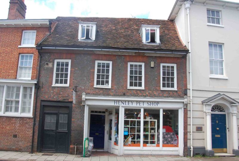
2. Early C18. Grey brick with red brick window dressings. Southern end wall now rebuilt as 2 bays have been removed from No 67 to allow extension to No 65. Wide moulded eaves cornice, old tiled roof. 2 storeys and dormers. 4 windows on 1st floor, sashes in flush frames with glazing bars. Ground floor has door and window under arch to rear at south end and C19 shop front with cornice and end stops. Side door. Only vertical glazing bars remain to shop window. 6 panelled house door, with small rectangular fanlight.
Nos 45, 45A, and 47 and Nos 53 to 81 (odd) form a group with Nos 44 to 52 (even) and Nos 60 to 64 (even) opposite and with No 2 New Street.
Listing NGR: SU7606382861
External links are from the relevant listing authority and, where applicable, Wikidata. Wikidata IDs may be related buildings as well as this specific building. If you want to add or update a link, you will need to do so by editing the Wikidata entry.


Other nearby listed buildings