Approximate Location Map
Large Map »
Latitude: 53.1426 / 53°8'33"N
Longitude: -0.7622 / 0°45'44"W
OS Eastings: 482890
OS Northings: 361319
OS Grid: SK828613
Mapcode National: GBR CKR.S51
Mapcode Global: WHFHB.888N
Plus Code: 9C5X46VQ+24
Entry Name: The Thatched Cottage and boundary wall
Listing Date: 17 October 1984
Grade: II*
Source: Historic England
Source ID: 1369947
English Heritage Legacy ID: 242554
ID on this website: 101369947
Location: Collingham, Newark and Sherwood, Nottinghamshire, NG23
County: Nottinghamshire
District: Newark and Sherwood
Civil Parish: Collingham
Built-Up Area: Collingham
Traditional County: Nottinghamshire
Lieutenancy Area (Ceremonial County): Nottinghamshire
Church of England Parish: Collingham
Church of England Diocese: Southwell and Nottingham
Tagged with: Building Thatched cottage
This list entry was subject to a Minor Amendment on 12 March 2021 to update the name and address and reformat the text to current standards.
SK 8261-8361
10/29
COLLINGHAM
THE GREEN (south side)
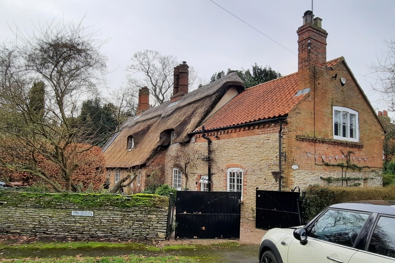
The Thatched Cottage and boundary wall
(Formerly listed as Thatch Cottage and Boundary Wall)
GV
II*
Cottage, late C16 and late C17 with late C18 extension to north. Brick on rubble plinth and timber framed with steep pitched thatched roof and shallow pantile roof, two pairs of large C19 ridge stacks. One and a half storeys, five bays. Off-centre C20 timber porch with C20 half glazed door flanked by two C19 two-light Yorkshire sashes, that to north with segmental head; to south C20 single glazing bar top hung casement and single C20 three-light glazing bar casement, both with timber lintels. South gable has C19 gabled brick porch with C19 single light glazing bar casement above. C18 extension to north, coursed blue lias rubble and brick, dentillated eaves, pantile roof, single gable stack. Single storey with garret. A single C19 single light top hung casement and a single C19 two-light Yorkshire sash with segmental head. In the north gable, a single C19 three-light Yorkshire sash.
Interior has substantial remains of an aisled hall or barn, with arched braces and blackened timbers. Some stud partitions, the C17 timber staircase, and chamfered spine beams also survive.
Outside, boundary wall, C18. Coursed blue lias rubble with rubble coping. Ramp changing height from approximately 1 metre to approximately 1.5 metres.
Listing NGR: SK8289061319
External links are from the relevant listing authority and, where applicable, Wikidata. Wikidata IDs may be related buildings as well as this specific building. If you want to add or update a link, you will need to do so by editing the Wikidata entry.


Other nearby listed buildings
